
Spenden
Rüste dich für dein nächstes Abenteuer:
Als Amazon-Partner verdient diese Seite an qualifizierten Käufen, ohne dass Ihnen zusätzliche Kosten entstehen.
Topografische Karte Laji Shan
Klicken Sie auf die Karte, um die Höhe anzuzeigen.
Spenden
Rüste dich für dein nächstes Abenteuer:
Als Amazon-Partner verdient diese Seite an qualifizierten Käufen, ohne dass Ihnen zusätzliche Kosten entstehen.
Über diese Karte
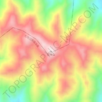
Name: Topografische Karte Laji Shan, Höhe, Relief.
Ort: Laji Shan, Ping'an District, Haidong, Qinghai, China (36.26093 102.01936 36.26103 102.01946)
Durchschnittliche Höhe: 3’493 m
Minimale Höhe: 3’196 m
Maximale Höhe: 3’719 m
Spenden
Rüste dich für dein nächstes Abenteuer:
Als Amazon-Partner verdient diese Seite an qualifizierten Käufen, ohne dass Ihnen zusätzliche Kosten entstehen.
Andere topografische Karten
Klicken Sie auf eine Karte, um ihre Topografie, ihre Höhe und ihr Relief anzuzeigen.
Spenden
Rüste dich für dein nächstes Abenteuer:
Als Amazon-Partner verdient diese Seite an qualifizierten Käufen, ohne dass Ihnen zusätzliche Kosten entstehen.
Haidong
Haidong has a cool semi-arid climate (Köppen BSk) characterised by warm to very warm summers, freezing but extremely dry winters, and large diurnal temperature ranges. Temperatures are warmer than anywhere else in Qinghai due to the relatively low altitude, although minima in winter still typically fall below…
Durchschnittliche Höhe: 2’758 m
Spenden
Rüste dich für dein nächstes Abenteuer:
Als Amazon-Partner verdient diese Seite an qualifizierten Käufen, ohne dass Ihnen zusätzliche Kosten entstehen.
Spenden
Rüste dich für dein nächstes Abenteuer:
Als Amazon-Partner verdient diese Seite an qualifizierten Käufen, ohne dass Ihnen zusätzliche Kosten entstehen.
Qilian County
Qilian County is in the middle part of the Qilian Mountains, the average altitude of 3169m, 4000m altitude above the alpine zone of snow all year round.The elevation of the county town is 2787m.
Durchschnittliche Höhe: 3’253 m
Spenden
Rüste dich für dein nächstes Abenteuer:
Als Amazon-Partner verdient diese Seite an qualifizierten Käufen, ohne dass Ihnen zusätzliche Kosten entstehen.
Spenden
Rüste dich für dein nächstes Abenteuer:
Als Amazon-Partner verdient diese Seite an qualifizierten Käufen, ohne dass Ihnen zusätzliche Kosten entstehen.
Yushu
With elevations above 3,600 metres (12,000 ft), the prefecture has a harsh climate, with long, cold winters, and short, rainy, and cool to warm summers. Specifically, in the Köppen system, the prefecture ranges from the alpine variation of the subarctic climate (Köppen Dwc), to a full alpine climate (Köppen…
Durchschnittliche Höhe: 4’472 m
Spenden
Rüste dich für dein nächstes Abenteuer:
Als Amazon-Partner verdient diese Seite an qualifizierten Käufen, ohne dass Ihnen zusätzliche Kosten entstehen.
Spenden
Rüste dich für dein nächstes Abenteuer:
Als Amazon-Partner verdient diese Seite an qualifizierten Käufen, ohne dass Ihnen zusätzliche Kosten entstehen.
Tanggulashan
The Tanggula settlement, also known as Marquwo, Tuotuoheyan, or Togtogquwo, is located at 4,535 metres (14,879 ft) above sea level in the central part of Tanggula Mountains, as the town's name indicates. The town's area includes the Geladaindong Peak, a mountain which stands at 6,621 metres (21,722 ft) in…
Durchschnittliche Höhe: 4’571 m
Golog
The lay of the land of the prefecture is largely determined by the Amne Machin mountain range (max elevation 6,282 m), which runs in the general northwest- to-southeast direction across the entire prefecture, and beyond. The existence of the ridge results in one of the great bends of the Yellow River, which…
Durchschnittliche Höhe: 4’030 m
Spenden
Rüste dich für dein nächstes Abenteuer:
Als Amazon-Partner verdient diese Seite an qualifizierten Käufen, ohne dass Ihnen zusätzliche Kosten entstehen.
1m Solar Telescope at 4000m elevation platform, NAOC
China > Qinghai > Mangnai City > Lenghu
Durchschnittliche Höhe: 3’926 m
Spenden
Rüste dich für dein nächstes Abenteuer:
Als Amazon-Partner verdient diese Seite an qualifizierten Käufen, ohne dass Ihnen zusätzliche Kosten entstehen.
Qumarlêb County
With an elevation of around 4,200 metres (14,000 ft), Qumarlêb County has an alpine climate (Köppen ETH), with long, very cold winters, and short, cool and rainy summers. Average low temperatures are below freezing from mid September to late May; however, due to the wide diurnal temperature variation,…
Durchschnittliche Höhe: 4’505 m