
Topografische Karte Ottawa
Interaktive Karte
Klicken Sie auf die Karte, um die Höhe anzuzeigen.
Über diese Karte
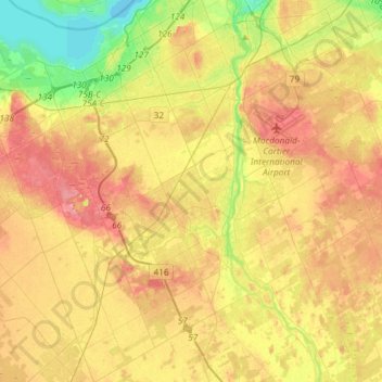
Name: Topografische Karte Ottawa, Höhe, Relief.
Ort: Nepean, Ottawa, Eastern Ontario, Ontario, Kanada (45.18041 -75.92008 45.38794 -75.68889)
Durchschnittliche Höhe: 93 m
Minimale Höhe: 51 m
Maximale Höhe: 130 m
Andere topografische Karten
Klicken Sie auf eine Karte, um ihre Topografie, ihre Höhe und ihr Relief anzuzeigen.
Cumberland
Kanada > Ontario > Ottawa > Cumberland
Cumberland, Sheenboro Crescent, Fallingbrook, Orléans, Cumberland, Ottawa, Eastern Ontario, Ontario, K4A 3S1, Kanada
Durchschnittliche Höhe: 75 m
Cumberland
Kanada > Ontario > Ottawa > Cumberland
Cumberland, Ottawa, Eastern Ontario, Ontario, Kanada
Durchschnittliche Höhe: 75 m
Victoria Island
Victoria Island, (Old) Ottawa, Ottawa, Ontario, K1R 1C5, Kanada
Durchschnittliche Höhe: 126 m