
Topografische Karte Bottineau
Interaktive Karte
Klicken Sie auf die Karte, um die Höhe anzuzeigen.
Über diese Karte
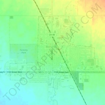
Name: Topografische Karte Bottineau, Höhe, Relief.
Ort: Bottineau, Bottineau County, North Dakota, United States (48.81635 -100.46232 48.83515 -100.42655)
Durchschnittliche Höhe: 498 m
Minimale Höhe: 483 m
Maximale Höhe: 517 m
According to the United States Census Bureau, the city has a total area of 1.09 square miles (2.82 km2), all of it land. The elevation is 1,637 feet (499 m) above sea level.