
Topografische Karte Burton-on-Trent
Interaktive Karte
Klicken Sie auf die Karte, um die Höhe anzuzeigen.
Über diese Karte
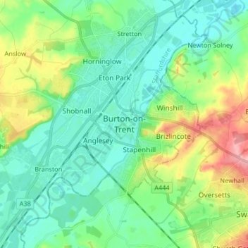
Name: Topografische Karte Burton-on-Trent, Höhe, Relief.
Durchschnittliche Höhe: 69 m
Minimale Höhe: 38 m
Maximale Höhe: 149 m
Burton is about 109 miles (175 km) north west of London, about 30 miles north east of Birmingham, the UK's second largest city and about 23 miles east of the county town Stafford. It is at the easternmost border of the county of Staffordshire with Derbyshire, its suburbs and the course of the River Trent forming part of the county boundary. It is also near the south-eastern terminus of the Trent and Mersey Canal. Burton lies within the northern boundary of the National Forest. The town centre is on the western bank of the River Trent in a valley bottom; its average elevation is about 50 metres above sea level; the village of Winshill and the suburb of Stapenhill rise to 130 m and 100 m respectively.
Andere topografische Karten
Klicken Sie auf eine Karte, um ihre Topografie, ihre Höhe und ihr Relief anzuzeigen.
Gratwich
United Kingdom > England > Staffordshire > East Staffordshire > Kingstone
Gratwich, Kingstone, East Staffordshire, Staffordshire, England, ST14 8WE, United Kingdom
Durchschnittliche Höhe: 143 m