
Topografische Karte Box Hill North
Interaktive Karte
Klicken Sie auf die Karte, um die Höhe anzuzeigen.
Über diese Karte
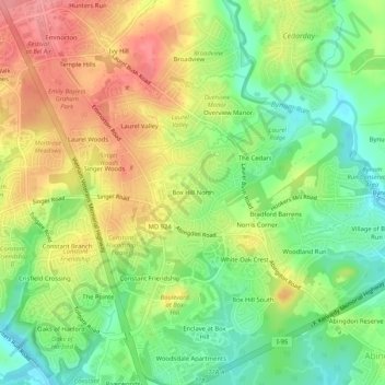
Name: Topografische Karte Box Hill North, Höhe, Relief.
Durchschnittliche Höhe: 55 m
Minimale Höhe: 13 m
Maximale Höhe: 102 m
Andere topografische Karten
Klicken Sie auf eine Karte, um ihre Topografie, ihre Höhe und ihr Relief anzuzeigen.
Castleton
United States > Maryland > Harford County > Castleton
Castleton, Harford County, Maryland, 21034, United States
Durchschnittliche Höhe: 81 m
Box Hill South
United States > Maryland > Harford County > Box Hill South
Box Hill South, Harford County, Maryland, 21009, United States
Durchschnittliche Höhe: 40 m