
Topografische Karte Quandary Peak
Interaktive Karte
Klicken Sie auf die Karte, um die Höhe anzuzeigen.
Über diese Karte
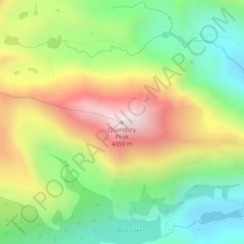
Name: Topografische Karte Quandary Peak, Höhe, Relief.
Durchschnittliche Höhe: 3’833 m
Minimale Höhe: 3’466 m
Maximale Höhe: 4’343 m
Quandary Peak is the highest summit of the Tenmile Range in the Rocky Mountains of North America and is the most commonly climbed fourteener in Colorado. It has nearly the same elevation as Castle Peak and Mount Evans. It lies in Summit County and within the White River National Forest about 6 miles (10 km) south-southwest of the town of Breckenridge.
Andere topografische Karten
Klicken Sie auf eine Karte, um ihre Topografie, ihre Höhe und ihr Relief anzuzeigen.
Crested Butte
United States of America > Colorado > Crested Butte
Crested Butte, Gunnison County, Colorado, 81224, United States of America
Durchschnittliche Höhe: 2’798 m
Dream Lake
United States of America > Colorado
Dream Lake, Flat Top Mountain Trail, Larimer County, Colorado, United States of America
Durchschnittliche Höhe: 3’150 m
Dolores County
United States of America > Colorado
Dolores County, Colorado, United States of America
Durchschnittliche Höhe: 2’385 m
Wild Horse
United States of America > Colorado > Wild Horse
Wild Horse, Pueblo County, Colorado, United States of America
Durchschnittliche Höhe: 1’496 m
Centennial
United States of America > Colorado > Centennial
Centennial, Arapahoe County, Colorado, United States of America
Durchschnittliche Höhe: 1’722 m
Rio Grande County
United States of America > Colorado
Rio Grande County, Colorado, United States of America
Durchschnittliche Höhe: 2’771 m
Rio Blanco County
United States of America > Colorado
Rio Blanco County, Colorado, United States of America
Durchschnittliche Höhe: 2’161 m
Idaho Springs
United States of America > Colorado > Idaho Springs
Idaho Springs, Clear Creek County, Colorado, United States of America
Durchschnittliche Höhe: 2’684 m
White Hills
United States of America > Colorado
White Hills, Custer County, Colorado, 81252, United States of America
Durchschnittliche Höhe: 2’447 m
Mount Arthur
United States of America > Colorado
Mount Arthur, El Paso County, Colorado, United States of America
Durchschnittliche Höhe: 3’002 m
Telluride
United States of America > Colorado > Telluride
Telluride, San Miguel County, Colorado, United States of America
Durchschnittliche Höhe: 3’125 m
Alamosa County
United States of America > Colorado
Alamosa County, Colorado, United States of America
Durchschnittliche Höhe: 2’359 m
Golden
United States of America > Colorado > Golden
Golden, Jefferson County, Colorado, United States of America
Durchschnittliche Höhe: 1’940 m
El Paso County
United States of America > Colorado
El Paso County, Colorado, United States of America
Durchschnittliche Höhe: 1’958 m