
Topografische Karte Lorca
Interaktive Karte
Klicken Sie auf die Karte, um die Höhe anzuzeigen.
Über diese Karte
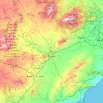
Name: Topografische Karte Lorca, Höhe, Relief.
Ort: Lorca, Alto Guadalentín, España (37.42102 -2.01265 37.97018 -1.39668)
Durchschnittliche Höhe: 537 m
Minimale Höhe: -1 m
Maximale Höhe: 1’561 m
La altitud oscila entre los 1529 metros del Morrón del Ribazuelo (Sierra de Ponce) y el nivel del mar en la costa. El núcleo urbano se alza a 353 metros sobre el nivel del mar.
Andere topografische Karten
Klicken Sie auf eine Karte, um ihre Topografie, ihre Höhe und ihr Relief anzuzeigen.
Garita
España > Alto Guadalentín > Lorca
Garita, Lorca, Alto Guadalentín, España
Durchschnittliche Höhe: 837 m
El Palancar
España > Alto Guadalentín > Lorca
El Palancar, Zarzadilla de Totana, Lorca, Alto Guadalentín, 30800, España
Durchschnittliche Höhe: 822 m
Esparragal
España > Alto Guadalentín > Puerto Lumbreras
Esparragal, Puerto Lumbreras, Alto Guadalentín, 30817, España
Durchschnittliche Höhe: 336 m
Góñar
España > Alto Guadalentín > Puerto Lumbreras
Góñar, Puerto Lumbreras, Alto Guadalentín, España
Durchschnittliche Höhe: 545 m
Torrealvilla
España > Alto Guadalentín > Lorca
Torrealvilla, Lorca, Alto Guadalentín, España
Durchschnittliche Höhe: 503 m
Molino de Viento
España > Alto Guadalentín > Lorca
Molino de Viento, Lorca, Alto Guadalentín, España
Durchschnittliche Höhe: 324 m