
Topografische Karte Jaffrey
Interaktive Karte
Klicken Sie auf die Karte, um die Höhe anzuzeigen.
Über diese Karte
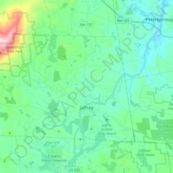
Name: Topografische Karte Jaffrey, Höhe, Relief.
Durchschnittliche Höhe: 351 m
Minimale Höhe: 216 m
Maximale Höhe: 942 m
Thorndike Pond is in the north, and Contoocook Lake is on the southern boundary. Mount Monadnock, elevation 3,165 feet (965 m) and the highest point in Jaffrey as well as Cheshire County, is in the northwest. Jaffrey lies mostly within the Merrimack River watershed, via the Contoocook River in the eastern part of the town, with the northwest corner of town lying in the Ashuelot River watershed, part of the larger Connecticut River watershed.
Andere topografische Karten
Klicken Sie auf eine Karte, um ihre Topografie, ihre Höhe und ihr Relief anzuzeigen.
Keene
United States > New Hampshire > Cheshire County
Keene, Cheshire County, New Hampshire, United States
Durchschnittliche Höhe: 263 m
Rindge
United States > New Hampshire > Cheshire County
Rindge, Cheshire County, New Hampshire, United States
Durchschnittliche Höhe: 343 m
North Swanzey
United States > New Hampshire > Cheshire County > Keene > North Swanzey
North Swanzey, Keene, Cheshire County, New Hampshire, 03435, United States
Durchschnittliche Höhe: 169 m
Harrisville
United States > New Hampshire > Cheshire County
Harrisville, Cheshire County, New Hampshire, 03450, United States
Durchschnittliche Höhe: 422 m