
Topografische Karte Al-Fashir
Interaktive Karte
Klicken Sie auf die Karte, um die Höhe anzuzeigen.
Über diese Karte
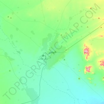
Name: Topografische Karte Al-Fashir, Höhe, Relief.
Ort: Al-Fashir, Al Fasher, North Darfur State, Sudan (13.46382 25.19556 13.78382 25.51556)
Durchschnittliche Höhe: 753 m
Minimale Höhe: 684 m
Maximale Höhe: 1’059 m
Al Fashir, Al-Fashir or El Fasher (Arabic: الفاشر) is the capital city of North Darfur, Sudan. It is a large town in the Darfur region of northwestern Sudan, 195 kilometres (121 mi) northeast of Nyala, Sudan. A historical caravan post, Al-Fashir is located at an elevation of about 700 metres (2,300 ft). The town serves as an agricultural marketing point for the cereals and fruits grown in the surrounding region. Al-Fashir is linked by road with both Geneina and Umm Keddada. Al-Fashir had 264,734 residents as of 2006, an increase from 2001, when the population was estimated to be 178,500.
Andere topografische Karten
Klicken Sie auf eine Karte, um ihre Topografie, ihre Höhe und ihr Relief anzuzeigen.
Galala
Sudan > North Darfur State > Al Fasher
Galala, Al Fasher, North Darfur State, Sudan
Durchschnittliche Höhe: 919 m