
Topografische Karte Nyoma
Interaktive Karte
Klicken Sie auf die Karte, um die Höhe anzuzeigen.
Über diese Karte
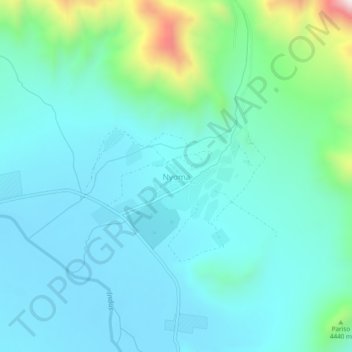
Name: Topografische Karte Nyoma, Höhe, Relief.
Ort: Nyoma, Leh Tehsil, Leh District, Ladakh, 194404, India (33.18548 78.62966 33.22548 78.66966)
Durchschnittliche Höhe: 4’260 m
Minimale Höhe: 4’133 m
Maximale Höhe: 4’850 m
The airbase received the Wildlife Board's forest clearance in 2022 to expand into 508 hectare of land inside Changthang Wildlife Sanctuary. The Government of India announced in January 2023 that this airstrip will be upgraded in two years by the end of 2024 at a cost of Rs.214 crore (US$27 m) to a 1,235 acre full fighter jet airbase at 13,700 feet (4,200 m) elevation with an expanded 2.7 km paved runway with ability to recover airplanes and minor repair facilities. Aeroplanes can land from both directions on this airstrip. Chushul, Fukche & Leh are other nearby airbases & ALG airstrips.
Andere topografische Karten
Klicken Sie auf eine Karte, um ihre Topografie, ihre Höhe und ihr Relief anzuzeigen.
Leh
India > Ladakh > Leh Tehsil
Leh, Leh Tehsil, Leh District, Ladakh, India
Durchschnittliche Höhe: 3’653 m
Dungti
India > Ladakh > Leh Tehsil
Dungti, Leh Tehsil, Leh District, Ladakh, India
Durchschnittliche Höhe: 4’281 m
Mudh
India > Ladakh > Leh Tehsil
Mudh, Leh Tehsil, Leh District, Ladakh, 194404, India
Durchschnittliche Höhe: 4’324 m
Mahe
India > Ladakh > Leh Tehsil
Mahe, Leh Tehsil, Leh District, Ladakh, India
Durchschnittliche Höhe: 4’403 m
Nimo
India > Ladakh > Leh Tehsil
Nimo, Leh Tehsil, Leh District, Ladakh, India
Durchschnittliche Höhe: 3’282 m
Sakti
India > Ladakh > Leh Tehsil
Sakti, Leh Tehsil, Leh district, Ladakh, India
Durchschnittliche Höhe: 3’842 m
Pharka
India > Ladakh > Leh Tehsil > Spituk
Pharka, Spituk, Leh Tehsil, Leh district, Ladakh, India
Durchschnittliche Höhe: 3’269 m
Lato
India > Ladakh > Leh Tehsil
Lato, Leh Tehsil, Leh district, Ladakh, India
Durchschnittliche Höhe: 4’268 m
Kang Yatse 4 North
India > Ladakh > Leh Tehsil
Kang Yatse 4 North, Leh Tehsil, Leh district, Ladakh, India
Durchschnittliche Höhe: 5’759 m
Phyang
India > Ladakh > Leh Tehsil
Phyang, Leh Tehsil, Leh district, Ladakh, 194101, India
Durchschnittliche Höhe: 3’742 m
Khardung La
India > Ladakh > Leh Tehsil
Khardung La, Leh Tehsil, Leh district, Ladakh, India
Durchschnittliche Höhe: 5’236 m
Chinese claimed Pangong Tso area
India > Ladakh > Leh Tehsil
Chinese claimed Pangong Tso area, Leh Tehsil, Leh district, Ladakh, India
Durchschnittliche Höhe: 4’361 m
Korzok Kangri
India > Ladakh > Leh Tehsil
Korzok Kangri, Leh Tehsil, Leh district, Ladakh, India
Durchschnittliche Höhe: 5’635 m
Chemre
India > Ladakh > Leh Tehsil > Chemre
Chemre, Leh Tehsil, Leh district, Ladakh, India
Durchschnittliche Höhe: 3’711 m
Shey
India > Ladakh > Leh Tehsil > Shey
Shey, Leh Tehsil, Leh district, Ladakh, 194201, India
Durchschnittliche Höhe: 3’282 m
Spituk
India > Ladakh > Leh Tehsil > Spituk
Spituk, Leh Tehsil, Leh district, Ladakh, India
Durchschnittliche Höhe: 3’253 m
Stok
India > Ladakh > Leh Tehsil
Stok, Leh Tehsil, Leh district, Ladakh, India
Durchschnittliche Höhe: 3’580 m
Tso Moriri
India > Ladakh > Leh Tehsil > Karzok
Tso Moriri, Karzok, Leh Tehsil, Leh district, Ladakh, India
Durchschnittliche Höhe: 5’044 m
Chumathang
India > Ladakh > Leh Tehsil
Chumathang, Leh Tehsil, Leh District, Ladakh, India
Durchschnittliche Höhe: 4’335 m