
Topografische Karte Lesser Slave River
Interaktive Karte
Klicken Sie auf die Karte, um die Höhe anzuzeigen.
Über diese Karte
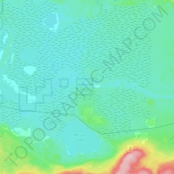
Name: Topografische Karte Lesser Slave River, Höhe, Relief.
Durchschnittliche Höhe: 592 m
Minimale Höhe: 570 m
Maximale Höhe: 748 m
Andere topografische Karten
Klicken Sie auf eine Karte, um ihre Topografie, ihre Höhe und ihr Relief anzuzeigen.
Municipal District of Willow Creek
Municipal District of Willow Creek, Alberta, Kanada
Durchschnittliche Höhe: 1’231 m
Crowfoot Glacier
Crowfoot Glacier, Crowfoot Mountain Approach Route, Alberta, Kanada
Durchschnittliche Höhe: 2’550 m
Peyto Glacier
Peyto Glacier, Trapper Peak Route, Columbia-Shuswap Regional District, Alberta, Kanada
Durchschnittliche Höhe: 2’421 m
North Saskatchewan River
North Saskatchewan River, County of Two Hills, Alberta, T5N 1J9, Kanada
Durchschnittliche Höhe: 833 m