
Topografische Karte Dublin
Interaktive Karte
Klicken Sie auf die Karte, um die Höhe anzuzeigen.
Über diese Karte
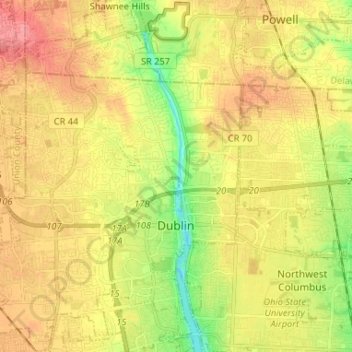
Name: Topografische Karte Dublin, Höhe, Relief.
Durchschnittliche Höhe: 275 m
Minimale Höhe: 232 m
Maximale Höhe: 312 m
Located on the Glaciated Allegheny Plateau, Dublin has a relatively flat topography. Nevertheless, there are numerous ravines surrounding the tributaries of the Scioto River, which make for steep cliffs in some areas. Elevations range from 780 feet (240 m) above sea level where the Scioto River leaves the city at Hayden Run Road, while the high point is 1,000 feet (300 m) at Glacier Ridge Metro Park.
Andere topografische Karten
Klicken Sie auf eine Karte, um ihre Topografie, ihre Höhe und ihr Relief anzuzeigen.
Worthington
United States > Ohio > Franklin County
Worthington, Sharon Township, Franklin County, Ohio, 43085, United States
Durchschnittliche Höhe: 262 m
Grandview Heights
United States > Ohio > Franklin County
Grandview Heights, Franklin County, Ohio, United States
Durchschnittliche Höhe: 232 m
Shepard
United States > Ohio > Franklin County > Columbus
Shepard, Columbus, Franklin County, Ohio, 43129, United States
Durchschnittliche Höhe: 245 m
Madison Township
United States > Ohio > Franklin County
Madison Township, Franklin County, Ohio, United States
Durchschnittliche Höhe: 232 m
Columbus
United States > Ohio > Franklin County
Columbus, Franklin County, Ohio, United States
Durchschnittliche Höhe: 261 m
Columbus
United States > Ohio > Franklin County > Columbus
Columbus, Franklin County, Ohio, 43216, United States
Durchschnittliche Höhe: 255 m
Riverlea
United States > Ohio > Franklin County > Riverlea
Riverlea, Sharon Township, Franklin County, Ohio, United States
Durchschnittliche Höhe: 247 m
Bexley
United States > Ohio > Franklin County > Bexley > Bexley
Bexley, Franklin County, Ohio, 43209, United States
Durchschnittliche Höhe: 243 m
Franklin County
United States > Ohio > Franklin County
Franklin County, Ohio, United States
Durchschnittliche Höhe: 262 m
Galloway
United States > Ohio > Franklin County
Galloway, Prairie Township, Franklin County, Ohio, 43119, United States
Durchschnittliche Höhe: 276 m
Bexley
United States > Ohio > Franklin County
Bexley, Franklin County, Ohio, 43209, United States
Durchschnittliche Höhe: 240 m