
Topografische Karte Old Saybrook
Interaktive Karte
Klicken Sie auf die Karte, um die Höhe anzuzeigen.
Über diese Karte
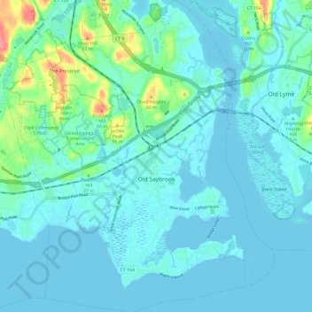
Name: Topografische Karte Old Saybrook, Höhe, Relief.
Durchschnittliche Höhe: 11 m
Minimale Höhe: -2 m
Maximale Höhe: 78 m
Andere topografische Karten
Klicken Sie auf eine Karte, um ihre Topografie, ihre Höhe und ihr Relief anzuzeigen.
Essex
United States > Connecticut > Lower Connecticut River Valley Planning Region
Essex, Lower Connecticut River Valley Planning Region, Connecticut, United States
Durchschnittliche Höhe: 26 m
Brazos Quarry Pond
United States > Connecticut > Lower Connecticut River Valley Planning Region > Portland
Brazos Quarry Pond, Portland, Lower Connecticut River Valley Planning Region, Connecticut, United States
Durchschnittliche Höhe: 20 m
Clinton Beach
United States > Connecticut > Lower Connecticut River Valley Planning Region > Clinton
Clinton Beach, Clinton, Lower Connecticut River Valley Planning Region, Connecticut, 06413, United States
Durchschnittliche Höhe: 4 m
East Hampton
United States > Connecticut > Lower Connecticut River Valley Planning Region
East Hampton, Lower Connecticut River Valley Planning Region, Connecticut, United States
Durchschnittliche Höhe: 129 m
Killingworth
United States > Connecticut > Lower Connecticut River Valley Planning Region
Killingworth, Lower Connecticut River Valley Planning Region, Connecticut, 06419, United States
Durchschnittliche Höhe: 102 m
Middlesex County
United States > Connecticut > Lower Connecticut River Valley Planning Region
Middlesex County, Lower Connecticut River Valley Planning Region, Connecticut, United States
Durchschnittliche Höhe: 81 m
Middletown
United States > Connecticut > Lower Connecticut River Valley Planning Region
Middletown, Lower Connecticut River Valley Planning Region, Connecticut, United States
Durchschnittliche Höhe: 76 m