
Topografische Karte Schertz
Interaktive Karte
Klicken Sie auf die Karte, um die Höhe anzuzeigen.
Über diese Karte
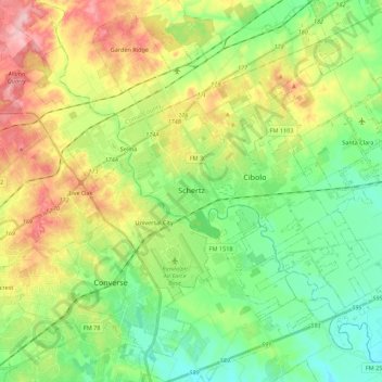
Name: Topografische Karte Schertz, Höhe, Relief.
Ort: Schertz, Guadalupe County, Texas, 78154, United States (29.46805 -98.30602 29.65928 -98.17674)
Durchschnittliche Höhe: 232 m
Minimale Höhe: 174 m
Maximale Höhe: 331 m
Andere topografische Karten
Klicken Sie auf eine Karte, um ihre Topografie, ihre Höhe und ihr Relief anzuzeigen.
Seguin
United States > Texas > Guadalupe County
Seguin, Guadalupe County, Texas, United States
Durchschnittliche Höhe: 172 m
Cibolo
United States > Texas > Guadalupe County
Cibolo, Guadalupe County, Texas, 78108, United States
Durchschnittliche Höhe: 220 m
Zorn
United States > Texas > Guadalupe County
Zorn, Guadalupe County, Texas, United States
Durchschnittliche Höhe: 169 m
Kingsbury
United States > Texas > Guadalupe County
Kingsbury, Guadalupe County, Texas, United States
Durchschnittliche Höhe: 166 m