
Topografische Karte Barnstead
Interaktive Karte
Klicken Sie auf die Karte, um die Höhe anzuzeigen.
Über diese Karte
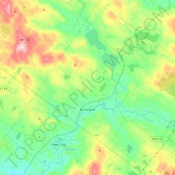
Name: Topografische Karte Barnstead, Höhe, Relief.
Ort: Barnstead, Belknap County, New Hampshire, United States (43.28444 -71.34881 43.41836 -71.15918)
Durchschnittliche Höhe: 221 m
Minimale Höhe: 117 m
Maximale Höhe: 422 m
Barnstead is a town in Belknap County, New Hampshire, United States. The population was 4,593 at the 2010 census. Home to the Suncook Lakes, Barnstead includes the villages of Center Barnstead, Barnstead Parade (identified as "Barnstead" on topographic maps) and South Barnstead.
Andere topografische Karten
Klicken Sie auf eine Karte, um ihre Topografie, ihre Höhe und ihr Relief anzuzeigen.
Lake Winnipesaukee
United States > New Hampshire > Belknap County > Alton
Lake Winnipesaukee, Alton, Belknap County, New Hampshire, 03226, United States
Durchschnittliche Höhe: 223 m
The Plains
United States > New Hampshire > Belknap County > Tilton
The Plains, Tilton, Belknap County, New Hampshire, 03252, United States
Durchschnittliche Höhe: 167 m
Mallard Cove
United States > New Hampshire > Belknap County > Laconia
Mallard Cove, Laconia, Belknap County, New Hampshire, 03246, United States
Durchschnittliche Höhe: 173 m
Sanbornton
United States > New Hampshire > Belknap County
Sanbornton, Belknap County, New Hampshire, 03269, United States
Durchschnittliche Höhe: 228 m
Gilford
United States > New Hampshire > Belknap County
Gilford, Belknap County, New Hampshire, 03249, United States
Durchschnittliche Höhe: 231 m
Tilton
United States > New Hampshire > Belknap County
Tilton, Belknap County, New Hampshire, United States
Durchschnittliche Höhe: 196 m
Meredith
United States > New Hampshire > Belknap County
Meredith, Belknap County, New Hampshire, 03253, United States
Durchschnittliche Höhe: 215 m