
Topografische Karte El Dorado Hills
Interaktive Karte
Klicken Sie auf die Karte, um die Höhe anzuzeigen.
Über diese Karte
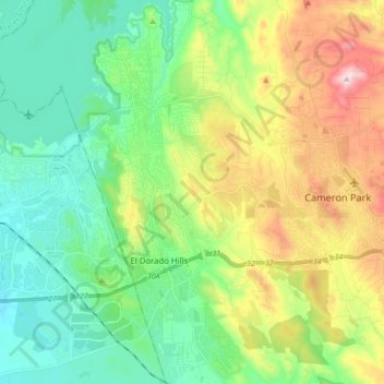
Name: Topografische Karte El Dorado Hills, Höhe, Relief.
Durchschnittliche Höhe: 254 m
Minimale Höhe: 81 m
Maximale Höhe: 622 m
El Dorado Hills (EDH), as defined by the 2010 census-designated place (CDP), is at the western border of El Dorado County, between the City of Folsom and the unincorporated community of Cameron Park. The northern limits of the CDP are Folsom Lake and the South Fork of the American River, where river rafters use Skunk Hollow and Salmon Falls as takeout landings. West of Latrobe Road, the south edge of the CDP follows railroad tracks formerly used by the Southern Pacific between the cities of Folsom and Placerville. East of Latrobe Road the south edge follows topography running roughly east–west.
Andere topografische Karten
Klicken Sie auf eine Karte, um ihre Topografie, ihre Höhe und ihr Relief anzuzeigen.
El Dorado Hills
United States > California > El Dorado County > Folsom
El Dorado Hills, Folsom, El Dorado County, CAL Fire Northern Region, California, 95762, United States
Durchschnittliche Höhe: 243 m