
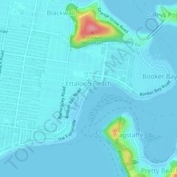
Topografische Karte Ettalong Beach
Interaktive Karte
Klicken Sie auf die Karte, um die Höhe anzuzeigen.
Über diese Karte
Name: Topografische Karte Ettalong Beach, Höhe, Relief.
Durchschnittliche Höhe: 9 m
Minimale Höhe: -4 m
Maximale Höhe: 103 m
Andere topografische Karten
Klicken Sie auf eine Karte, um ihre Topografie, ihre Höhe und ihr Relief anzuzeigen.
Somersby
Australia > New South Wales > Gosford
Somersby, Gosford, Central Coast Council, New South Wales, 2250, Australia
Durchschnittliche Höhe: 151 m
Kariong
Australia > New South Wales > Gosford
Kariong, Gosford, Central Coast Council, New South Wales, 2250, Australia
Durchschnittliche Höhe: 86 m
Narara
Australia > New South Wales > Gosford
Narara, Gosford, Central Coast Council, New South Wales, 2250, Australia
Durchschnittliche Höhe: 55 m
Robinson Creek
Australia > New South Wales > Gosford
Robinson Creek, Somersby, Gosford, Central Coast Council, New South Wales, 2250, Australia
Durchschnittliche Höhe: 229 m
Umina Beach
Australia > New South Wales > Gosford
Umina Beach, Gosford, Central Coast Council, New South Wales, 2257, Australia
Durchschnittliche Höhe: 38 m
Hawkesbury River
Australia > New South Wales > Gosford > Cowan
Hawkesbury River, Cowan, Gosford, Central Coast Council, New South Wales, 2083, Australia
Durchschnittliche Höhe: 82 m