Geolokalisieren

Topografische Karte Edgars Creek

Interaktive Karte

Klicken Sie auf die Karte, um die Höhe anzuzeigen.

Über diese Karte

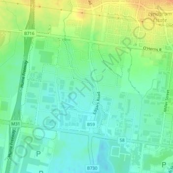
Name: Topografische Karte Edgars Creek, Höhe, Relief.

Ort: Edgars Creek, City of Whittlesea, 维多利亚州, 3076, 澳大利亚 (-37.64988 145.00053 -37.63496 145.00800)

Durchschnittliche Höhe: 136 m

Minimale Höhe: 121 m

Maximale Höhe: 161 m

Andere topografische Karten

Klicken Sie auf eine Karte, um ihre Topografie, ihre Höhe und ihr Relief anzuzeigen.

墨爾本

澳大利亚 > 维多利亚州

墨爾本, 维多利亚州, 澳大利亚

Durchschnittliche Höhe: 20 m

Trentham Falls

澳大利亚 > 维多利亚州 > Trentham

Trentham Falls, Trentham, Shire of Hepburn, 维多利亚州, 3458, 澳大利亚

Durchschnittliche Höhe: 689 m

Dandenong District

澳大利亚 > 维多利亚州 > 墨爾本

Dandenong District, 墨爾本, City of Greater Dandenong, 维多利亚州, 澳大利亚

Durchschnittliche Höhe: 40 m

Shire of Moira

澳大利亚 > 维多利亚州

Shire of Moira, 维多利亚州, 澳大利亚

Durchschnittliche Höhe: 125 m

Rutherglen

澳大利亚 > 维多利亚州 > Rutherglen

Rutherglen, Shire of Indigo, 维多利亚州, 3685, 澳大利亚

Durchschnittliche Höhe: 158 m

瑟尔

澳大利亚 > 维多利亚州 > 瑟尔

瑟尔, Shire of Wellington, 维多利亚州, 3850, 澳大利亚

Durchschnittliche Höhe: 8 m

Laen East

澳大利亚 > 维多利亚州

Laen East, Shire of Buloke, 维多利亚州, 澳大利亚

Durchschnittliche Höhe: 121 m

桑伯里

澳大利亚 > 维多利亚州 > 桑伯里

桑伯里, City of Darebin, 维多利亚州, 3071, 澳大利亚

Durchschnittliche Höhe: 54 m

City of Monash

澳大利亚 > 维多利亚州

City of Monash, 维多利亚州, 澳大利亚

Durchschnittliche Höhe: 78 m

霍索恩

澳大利亚 > 维多利亚州 > 霍索恩

霍索恩, City of Boroondara, 维多利亚州, 3122, 澳大利亚

Durchschnittliche Höhe: 33 m

库拉鲁

澳大利亚 > 维多利亚州

库拉鲁, City of Hume, 维多利亚州, 澳大利亚

Durchschnittliche Höhe: 145 m