
Topografische Karte Derry/Londonderry
Interaktive Karte
Klicken Sie auf die Karte, um die Höhe anzuzeigen.
Über diese Karte
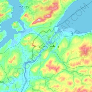
Name: Topografische Karte Derry/Londonderry, Höhe, Relief.
Durchschnittliche Höhe: 88 m
Minimale Höhe: -5 m
Maximale Höhe: 478 m
Derry is characterised by its distinctively hilly topography. The River Foyle forms a deep valley as it flows through the city, making Derry a place of very steep streets and sudden, startling views. The original walled city of Londonderry lies on a hill on the west bank of the River Foyle. In the past, the river branched and enclosed this wooded hill as an island; over the centuries, however, the western branch of the river dried up and became a low-lying and boggy district that is now called the Bogside.
Andere topografische Karten
Klicken Sie auf eine Karte, um ihre Topografie, ihre Höhe und ihr Relief anzuzeigen.
Coleraine
United Kingdom > Northern Ireland > County Londonderry
Coleraine, County Londonderry, Ulster, Northern Ireland, BT52 1EP, United Kingdom
Durchschnittliche Höhe: 40 m
Limavady
United Kingdom > Northern Ireland > County Londonderry
Limavady, County Londonderry, Ulster, Northern Ireland, BT49 0EP, United Kingdom
Durchschnittliche Höhe: 37 m