
Topografische Karte Ukhrul
Interaktive Karte
Klicken Sie auf die Karte, um die Höhe anzuzeigen.
Über diese Karte
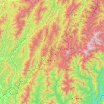
Name: Topografische Karte Ukhrul, Höhe, Relief.
Ort: Ukhrul, Ukhrul district, Manipur, India (24.93007 94.11643 25.28856 94.74068)
Durchschnittliche Höhe: 1’340 m
Minimale Höhe: 305 m
Maximale Höhe: 2’800 m
Ukhrul is located at 25°07′N 94°22′E / 25.12°N 94.37°E / 25.12; 94.37. It has an average elevation of 1,662 m (5,453 ft) above sea level. It has a wet summer and cold, dry winter.
Andere topografische Karten
Klicken Sie auf eine Karte, um ihre Topografie, ihre Höhe und ihr Relief anzuzeigen.
Leimakhong
India > Manipur > Saitu-Gamphazol
Leimakhong, Saitu-Gamphazol, Kangpokpi District, Manipur, 795136, India
Durchschnittliche Höhe: 967 m
Noney
India > Manipur > Tamenglong
Noney, Tamenglong, Manipur, 795159, India
Durchschnittliche Höhe: 670 m
Koubru
India > Manipur > Saitu-Gamphazol
Koubru, Saitu-Gamphazol, Kangpokpi, Manipur, India
Durchschnittliche Höhe: 2’146 m
Imphal
India > Manipur > Lamphelpat
Imphal, Lamphelpat, Imphal West District, Manipur, 795001, India
Durchschnittliche Höhe: 861 m
Iril River
Iril River, Sawombung, Imphal East, Manipur, 795118, India
Durchschnittliche Höhe: 992 m
Manipur River
India > Manipur > Chakpikarong
Manipur River, Chakpikarong, Chandel, Manipur, India
Durchschnittliche Höhe: 964 m
Khuga Dam
India > Manipur > Churachandpur
Khuga Dam, Churachandpur, Manipur, India
Durchschnittliche Höhe: 849 m
Lamphelpat
India > Manipur > Lamphelpat
Lamphelpat, Imphal West, Manipur, 795002, India
Durchschnittliche Höhe: 828 m
Nambul River
Nambul River, Imphal, Lamphelpat, Imphal West, Manipur, 795001, India
Durchschnittliche Höhe: 784 m
Singda Dam
Singda Dam, Saitu-Gamphazol, Kangpokpi, Manipur, India
Durchschnittliche Höhe: 948 m
Loktak Lake
India > Manipur > Nambol block > Karang
Loktak Lake, Karang, Nambol block, Bishnupur District, Manipur, India
Durchschnittliche Höhe: 771 m
Khuga River
Khuga River, Kumbi, Nambol, Bishnupur, Manipur, 795006, India
Durchschnittliche Höhe: 847 m