
Topografische Karte Elk
Interaktive Karte
Klicken Sie auf die Karte, um die Höhe anzuzeigen.
Über diese Karte
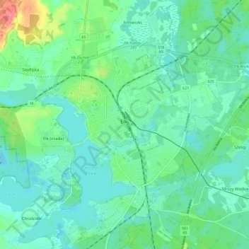
Name: Topografische Karte Elk, Höhe, Relief.
Ort: Elk, powiat ełcki, Warmian-Masurian Voivodeship, Poland (53.79015 22.31296 53.85772 22.40701)
Durchschnittliche Höhe: 129 m
Minimale Höhe: 112 m
Maximale Höhe: 183 m
Throughout their range, they live in forest and in forest edge habitat, similar to other deer species. In mountainous regions, they often dwell at higher elevations in summer, migrating down slope for winter. The highly adaptable elk also inhabit semi-deserts in North America, such as the Great Basin. Manchurian and Alashan wapiti are primarily forest dwellers and their smaller antler size is a likely adaptation to a forest environment.