
Topografische Karte Berkeley
Interaktive Karte
Klicken Sie auf die Karte, um die Höhe anzuzeigen.
Über diese Karte
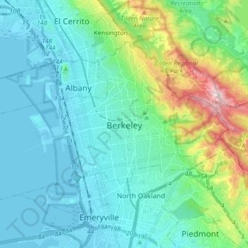
Name: Topografische Karte Berkeley, Höhe, Relief.
Ort: Berkeley, Alameda County, California, United States (37.83573 -122.36868 37.90669 -122.23420)
Durchschnittliche Höhe: 109 m
Minimale Höhe: -5 m
Maximale Höhe: 570 m
In 1866, Oakland's private College of California looked for a new site. It settled on a location north of Oakland along the foot of the Contra Costa Range (later called the Berkeley Hills) astride Strawberry Creek, at an elevation of about 500 feet (150 m) above the bay, commanding a view of the Bay Area and the Pacific Ocean through the Golden Gate.
Andere topografische Karten
Klicken Sie auf eine Karte, um ihre Topografie, ihre Höhe und ihr Relief anzuzeigen.
Fremont
United States > California > Alameda County
Fremont, Alameda County, California, United States
Durchschnittliche Höhe: 93 m
Davie Tennis Stadium
United States > California > Alameda County > Piedmont
Davie Tennis Stadium, Piedmont, Alameda County, California, United States
Durchschnittliche Höhe: 81 m
Pleasanton
United States > California > Alameda County
Pleasanton, Alameda County, California, United States
Durchschnittliche Höhe: 187 m
Dublin
United States > California > Alameda County
Dublin, Alameda County, California, 94568, United States
Durchschnittliche Höhe: 202 m
Albany
United States > California > Alameda County
Albany, Alameda County, CAL Fire Northern Region, California, United States
Durchschnittliche Höhe: 56 m
Oakland
United States > California > Alameda County
Oakland, Alameda County, California, United States
Durchschnittliche Höhe: 51 m
Piedmont
United States > California > Alameda County
Piedmont, Alameda County, California, 94611, United States
Durchschnittliche Höhe: 97 m
Hayward Acres
United States > California > Alameda County > Cherryland
Hayward Acres, Cherryland, Alameda County, California, United States
Durchschnittliche Höhe: 15 m
Fairview
United States > California > Alameda County > Fairview
Fairview, Alameda County, California, 94540, United States
Durchschnittliche Höhe: 122 m
San Leandro
United States > California > Alameda County
San Leandro, Alameda County, California, United States
Durchschnittliche Höhe: 21 m
Mission Peak Regional Preserve
United States > California > Alameda County > Fremont
Mission Peak Regional Preserve, Fremont, Alameda County, California, United States
Durchschnittliche Höhe: 322 m
Hayward
United States > California > Alameda County
Hayward, Alameda County, California, United States
Durchschnittliche Höhe: 77 m
Madeira Park
United States > California > Alameda County > Livermore
Madeira Park, Livermore, Alameda County, California, United States
Durchschnittliche Höhe: 160 m
Alamo Canal
United States > California > Alameda County > Dublin > Dougherty
Alamo Canal, Dougherty, Dublin, Alameda County, California, 94588, United States
Durchschnittliche Höhe: 115 m
Newark
United States > California > Alameda County
Newark, Alameda County, California, 94560, United States
Durchschnittliche Höhe: 4 m
Sunol
United States > California > Alameda County > Pleasanton
Sunol, Pleasanton, Alameda County, California, 94586, United States
Durchschnittliche Höhe: 222 m
Castro Valley
United States > California > Alameda County > Castro Valley
Castro Valley, Alameda County, California, United States
Durchschnittliche Höhe: 115 m
Alameda
United States > California > Alameda County
Alameda, Alameda County, CAL Fire Northern Region, California, United States
Durchschnittliche Höhe: 9 m
Livermore
United States > California > Alameda County
Livermore, Alameda County, California, 94550, United States
Durchschnittliche Höhe: 184 m
Union City
United States > California > Alameda County
Union City, Alameda County, CAL Fire Northern Region, California, 94587, United States
Durchschnittliche Höhe: 30 m
Emeryville
United States > California > Alameda County
Emeryville, Alameda County, California, 94608, United States
Durchschnittliche Höhe: 13 m