
Topografische Karte Kakinada
Interaktive Karte
Klicken Sie auf die Karte, um die Höhe anzuzeigen.
Über diese Karte
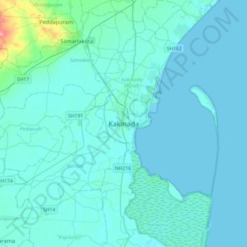
Name: Topografische Karte Kakinada, Höhe, Relief.
Durchschnittliche Höhe: 7 m
Minimale Höhe: -2 m
Maximale Höhe: 99 m
Kakinada is located at 16°56′N 82°13′E / 16.93°N 82.22°E / 16.93; 82.22. The 82-degrees east longitude passes through the city. It has an average elevation of 2 metres (6 ft), and many areas of the city are below sea level.
Andere topografische Karten
Klicken Sie auf eine Karte, um ihre Topografie, ihre Höhe und ihr Relief anzuzeigen.
Dharmavaram
India > Andhra Pradesh > Kakinada
Dharmavaram, Kakinada, East Godavari, Andhra Pradesh, 533001, India
Durchschnittliche Höhe: 41 m