
Topografische Karte Rewalsar
Interaktive Karte
Klicken Sie auf die Karte, um die Höhe anzuzeigen.
Über diese Karte
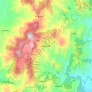
Name: Topografische Karte Rewalsar, Höhe, Relief.
Durchschnittliche Höhe: 1’283 m
Minimale Höhe: 814 m
Maximale Höhe: 1’927 m
Rewalsar is located at an altitude of 1360 m above sea level. It is connected to Mandi by a motorable road and is about 25 km from Mandi. Lying in the Southern Himalayan belt, winters in Rewalsar can be freezing, while summers are generally pleasant.
Andere topografische Karten
Klicken Sie auf eine Karte, um ihre Topografie, ihre Höhe und ihr Relief anzuzeigen.
Mandi
India > Himachal Pradesh > Mandi
Mandi, Mandi District, Himachal Pradesh, 175001, India
Durchschnittliche Höhe: 1’273 m
Nerchowk
India > Himachal Pradesh > Mandi
Nerchowk, Mandi, Mandi District, Himachal Pradesh, 175008, India
Durchschnittliche Höhe: 843 m
Kamand
India > Himachal Pradesh > Mandi
Kamand, Mandi, Himachal Pradesh, 175075, India
Durchschnittliche Höhe: 1’259 m
Beas River
India > Himachal Pradesh > Mandi > Pandoh
Beas River, Pandoh, Mandi, Himachal Pradesh, 175124, India
Durchschnittliche Höhe: 962 m