
Topografische Karte Stillwater
Interaktive Karte
Klicken Sie auf die Karte, um die Höhe anzuzeigen.
Über diese Karte
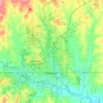
Name: Topografische Karte Stillwater, Höhe, Relief.
Ort: Stillwater, Payne County, Oklahoma, United States (36.07906 -97.14957 36.20450 -97.01539)
Durchschnittliche Höhe: 286 m
Minimale Höhe: 257 m
Maximale Höhe: 341 m
Andere topografische Karten
Klicken Sie auf eine Karte, um ihre Topografie, ihre Höhe und ihr Relief anzuzeigen.
Yale
United States > Oklahoma > Payne County
Yale, Payne County, Oklahoma, United States
Durchschnittliche Höhe: 265 m
The Botanic Garden at Oklahoma State University
United States > Oklahoma > Payne County > Stillwater
The Botanic Garden at Oklahoma State University, Stillwater, Payne County, Oklahoma, 74074, United States
Durchschnittliche Höhe: 275 m
Cushing
United States > Oklahoma > Payne County > Cushing
Cushing, Payne County, Oklahoma, 74023, United States
Durchschnittliche Höhe: 276 m
Stillwater
United States > Oklahoma > Payne County > Stillwater
Stillwater, Payne County, Oklahoma, 74077, United States
Durchschnittliche Höhe: 295 m