
Topografische Karte Maggie Valley
Interaktive Karte
Klicken Sie auf die Karte, um die Höhe anzuzeigen.
Über diese Karte
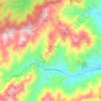
Name: Topografische Karte Maggie Valley, Höhe, Relief.
Ort: Maggie Valley, Haywood County, North Carolina, United States (35.50322 -83.11040 35.56502 -83.00542)
Durchschnittliche Höhe: 1’247 m
Minimale Höhe: 848 m
Maximale Höhe: 1’715 m
Andere topografische Karten
Klicken Sie auf eine Karte, um ihre Topografie, ihre Höhe und ihr Relief anzuzeigen.
Waynesville
United States > North Carolina > Haywood County
Waynesville, Haywood County, North Carolina, 28786, United States
Durchschnittliche Höhe: 921 m
Mount Lyn Lowry
United States > North Carolina > Haywood County
Mount Lyn Lowry, Haywood County, North Carolina, United States
Durchschnittliche Höhe: 1’586 m
Little Bird Falls
United States > North Carolina > Haywood County
Little Bird Falls, Haywood County, North Carolina, United States
Durchschnittliche Höhe: 1’347 m
Lake Junaluska
United States > North Carolina > Haywood County
Lake Junaluska, Haywood County, North Carolina, 28745, United States
Durchschnittliche Höhe: 862 m
Lake Logan
United States > North Carolina > Haywood County > Sunburst
Lake Logan, Sunburst, Haywood County, North Carolina, United States
Durchschnittliche Höhe: 1’061 m
Sugartree Licks
United States > North Carolina > Haywood County
Sugartree Licks, Haywood County, North Carolina, United States
Durchschnittliche Höhe: 1’505 m
Hazelwood
United States > North Carolina > Haywood County > Waynesville
Hazelwood, Waynesville, Haywood County, North Carolina, 28786, United States
Durchschnittliche Höhe: 888 m
Clyde
United States > North Carolina > Haywood County
Clyde, Haywood County, North Carolina, United States
Durchschnittliche Höhe: 802 m
The Glades
United States > North Carolina > Haywood County
The Glades, Haywood County, North Carolina, United States
Durchschnittliche Höhe: 1’164 m
Panther Creek
United States > North Carolina > Haywood County > Panther Creek
Panther Creek, Haywood County, North Carolina, United States
Durchschnittliche Höhe: 873 m