Geolokalisieren

Topografische Karte Imphal East

Interaktive Karte

Klicken Sie auf die Karte, um die Höhe anzuzeigen.

Über diese Karte

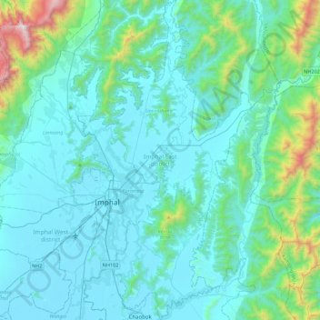
Name: Topografische Karte Imphal East, Höhe, Relief.

Ort: Imphal East, Manipur, India (24.65151 93.89542 25.05120 94.13485)

Durchschnittliche Höhe: 982 m

Minimale Höhe: 767 m

Maximale Höhe: 2’498 m

Imphal East District came into existence on 18-06-1997 with its headquarters at Porompat occupying the eastern part of Imphal District. The total area of District is 497 km2. approximately. The District is situated at an altitude 790 metres above the M.S. Level. The climate of the District is salubrious and Monsoon is tropical. The minimum temperature goes down to 0.6 degree Celsius in winter and 41 degree Celsius in summer. It has no rail network and hence communication is entirely dependent on roads except Jiribam District bordering Cachar District of Assam where there is a railhead. As of 2017, A new rail line is under construction and a railway station will be operational by 2019. The District is connected with N.H. 39, N.H. 53 and N.H. 150.

Wikipedia (CC-BY-SA 3.0)

Andere topografische Karten

Klicken Sie auf eine Karte, um ihre Topografie, ihre Höhe und ihr Relief anzuzeigen.

Leimakhong

India > Manipur > Saitu-Gamphazol

Leimakhong, Saitu-Gamphazol, Kangpokpi District, Manipur, 795136, India

Durchschnittliche Höhe: 967 m

Lamshang

India > Manipur > Lamsang

Lamshang, Lamsang, Imphal West District, Manipur, 795113, India

Durchschnittliche Höhe: 792 m

Noney

India > Manipur > Tamenglong

Noney, Tamenglong, Manipur, 795159, India

Durchschnittliche Höhe: 670 m

Maram

India > Manipur > Senapati

Maram, Senapati, Manipur, India

Durchschnittliche Höhe: 1’399 m

Koubru

India > Manipur > Saitu-Gamphazol

Koubru, Saitu-Gamphazol, Kangpokpi, Manipur, India

Durchschnittliche Höhe: 2’146 m

Imphal

India > Manipur > Lamphelpat

Imphal, Lamphelpat, Imphal West District, Manipur, 795001, India

Durchschnittliche Höhe: 861 m

Laikot

India > Manipur > Kangpoki

Laikot, Kangpoki, Kangpokpi, Manipur, India

Durchschnittliche Höhe: 2’391 m

Ukhrul

India > Manipur

Ukhrul, Manipur, India

Durchschnittliche Höhe: 1’052 m

Iril River

India > Manipur > Sawombung

Iril River, Sawombung, Imphal East, Manipur, 795118, India

Durchschnittliche Höhe: 992 m

Kakching

India > Manipur

Kakching, Manipur, India

Durchschnittliche Höhe: 925 m

Thoubal

India > Manipur

Thoubal, Ukhrul, Manipur, 795142, India

Durchschnittliche Höhe: 1’517 m

Senapati

India > Manipur

Senapati, Manipur, India

Durchschnittliche Höhe: 1’537 m

Wangoi

India > Manipur > Wangoi

Wangoi, Imphal West, Manipur, India

Durchschnittliche Höhe: 825 m

Tengnoupal

India > Manipur

Tengnoupal, Manipur, 795131, India

Durchschnittliche Höhe: 658 m

Nungba

India > Manipur > Nungba

Nungba, Noney, Manipur, 795147, India

Durchschnittliche Höhe: 691 m

Imphal West

India > Manipur

Imphal West, Manipur, India

Durchschnittliche Höhe: 906 m

Manipur River

India > Manipur > Chakpikarong

Manipur River, Chakpikarong, Chandel, Manipur, India

Durchschnittliche Höhe: 964 m

Khuga Dam

India > Manipur > Churachandpur

Khuga Dam, Churachandpur, Manipur, India

Durchschnittliche Höhe: 849 m

Jiribam

India > Manipur > Jiribam

Jiribam, Manipur, 795116, India

Durchschnittliche Höhe: 250 m

Lamphelpat

India > Manipur > Lamphelpat

Lamphelpat, Imphal West, Manipur, 795002, India

Durchschnittliche Höhe: 828 m

Churachandpur

India > Manipur

Churachandpur, Manipur, 795128, India

Durchschnittliche Höhe: 955 m

Kamjong

India > Manipur

Kamjong, Manipur, India

Durchschnittliche Höhe: 858 m

Lamphelpat

India > Manipur

Lamphelpat, Imphal West, Manipur, India

Durchschnittliche Höhe: 785 m

Pherzawl

India > Manipur > Pherzawl

Pherzawl, Tipaimukh, Pherzawl, Manipur, India

Durchschnittliche Höhe: 779 m

Moirang

India > Manipur > Moirang

Moirang, Bishnupur, Manipur, 795133, India

Durchschnittliche Höhe: 776 m

Thoubal

India > Manipur

Thoubal, Manipur, India

Durchschnittliche Höhe: 851 m

Nambul River

India > Manipur > Imphal

Nambul River, Imphal, Lamphelpat, Imphal West, Manipur, 795001, India

Durchschnittliche Höhe: 784 m

Kangpokpi

India > Manipur > Kangpokpi

Kangpokpi, Kangpoki, Kangpokpi, Manipur, 795129, India

Durchschnittliche Höhe: 1’328 m

Porompat

India > Manipur

Porompat, Imphal East, Manipur, India

Durchschnittliche Höhe: 821 m

Saikul

India > Manipur

Saikul, Kangpokpi, Manipur, India

Durchschnittliche Höhe: 1’082 m

Singda Dam

India > Manipur

Singda Dam, Saitu-Gamphazol, Kangpokpi, Manipur, India

Durchschnittliche Höhe: 948 m

Bishnupur

India > Manipur

Bishnupur, Manipur, India

Durchschnittliche Höhe: 901 m

Chandel

India > Manipur

Chandel, Manipur, 795127, India

Durchschnittliche Höhe: 966 m

Irang River

India > Manipur

Irang River, Noney, Manipur, 795147, India

Durchschnittliche Höhe: 616 m

Bishnupur

India > Manipur

Bishnupur, Manipur, 795126, India

Durchschnittliche Höhe: 843 m

Ukhrul

India > Manipur

Ukhrul, Ukhrul district, Manipur, India

Durchschnittliche Höhe: 1’340 m

Churachandpur

India > Manipur

Churachandpur, Manipur, India

Durchschnittliche Höhe: 932 m

Tamenglong

India > Manipur

Tamenglong, Manipur, India

Durchschnittliche Höhe: 817 m

Loktak Lake

India > Manipur > Nambol block > Karang

Loktak Lake, Karang, Nambol block, Bishnupur District, Manipur, India

Durchschnittliche Höhe: 771 m

Tuivai

India > Manipur

Tuivai, Pherzawl, Manipur, India

Durchschnittliche Höhe: 884 m

Khangabok

India > Manipur > Khangabok

Khangabok, Thoubal, Manipur, India

Durchschnittliche Höhe: 775 m

Tipaimukh

India > Manipur > Tipaimukh

Tipaimukh, Pherzawl, Manipur, 795143, India

Durchschnittliche Höhe: 190 m

Khuga River

India > Manipur > Kumbi

Khuga River, Kumbi, Nambol, Bishnupur, Manipur, 795006, India

Durchschnittliche Höhe: 847 m