
Topografische Karte Red Lake County
Interaktive Karte
Klicken Sie auf die Karte, um die Höhe anzuzeigen.
Über diese Karte
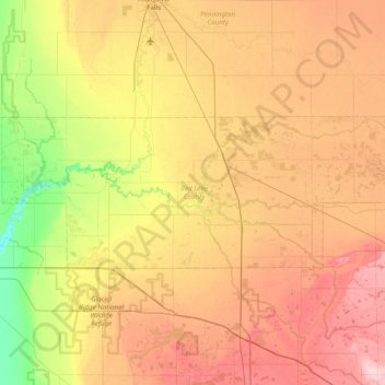
Name: Topografische Karte Red Lake County, Höhe, Relief.
Ort: Red Lake County, Minnesota, United States of America (47.76030 -96.48460 47.96593 -95.71173)
Durchschnittliche Höhe: 341 m
Minimale Höhe: 268 m
Maximale Höhe: 420 m
The Red Lake River flows southward into the county from Pennington. It is joined near Red Lake Falls by the Clearwater River; the combined flow (still known as the Red Lake River) flows southwestward to Huot, where it is augmented by the Black River which drains the NW part of the county. The Red Lake River then flows southwestward into Polk County. The county terrain consists of low rolling hills, etched by drainages and gullies. The area is devoted to agriculture. The county terrain slopes to the west, with its highest elevation on its SE corner, at 1,201' (366m) ASL. The county has a total area of 432 square miles (1,120 km2), of which 432 square miles (1,120 km2) is land and 0.09 square miles (0.23 km2) (0.02%) is water.
Andere topografische Karten
Klicken Sie auf eine Karte, um ihre Topografie, ihre Höhe und ihr Relief anzuzeigen.
Brooklyn Park
United States of America > Minnesota > Brooklyn Park
Brooklyn Park, Hennepin County, Minnesota, United States of America
Durchschnittliche Höhe: 265 m
Stevens County
United States of America > Minnesota
Stevens County, Minnesota, United States of America
Durchschnittliche Höhe: 345 m
Todd County
United States of America > Minnesota
Todd County, Minnesota, United States of America
Durchschnittliche Höhe: 403 m
Farmington
United States of America > Minnesota > Farmington
Farmington, Dakota County, Minnesota, 55024, United States of America
Durchschnittliche Höhe: 280 m
Fairmont
United States of America > Minnesota > Fairmont
Fairmont, Martin County, Minnesota, 56031, United States of America
Durchschnittliche Höhe: 361 m
Apple Valley
United States of America > Minnesota > Apple Valley
Apple Valley, Dakota County, Minnesota, 55124, United States of America
Durchschnittliche Höhe: 301 m
Greenbush
United States of America > Minnesota > Greenbush
Greenbush, Roseau County, Minnesota, 56726, United States of America
Durchschnittliche Höhe: 324 m
Lake Itasca
United States of America > Minnesota > Lake Itasca
Lake Itasca, Clearwater County, Minnesota, 56480, United States of America
Durchschnittliche Höhe: 460 m
Beaver Creek
United States of America > Minnesota > Beaver Creek
Beaver Creek, Rock County, Minnesota, 56116, United States of America
Durchschnittliche Höhe: 447 m
Brownton
United States of America > Minnesota > Brownton
Brownton, McLeod County, Minnesota, United States of America
Durchschnittliche Höhe: 314 m
Birchmont
United States of America > Minnesota > Birchmont
Birchmont, Beltrami County, Minnesota, 56601, United States of America
Durchschnittliche Höhe: 419 m
Erskine
United States of America > Minnesota > Erskine
Erskine, Polk County, Minnesota, United States of America
Durchschnittliche Höhe: 365 m
Etna Creek
United States of America > Minnesota
Etna Creek, Fillmore County, Minnesota, United States of America
Durchschnittliche Höhe: 404 m
Watson
United States of America > Minnesota > Watson
Watson, Chippewa County, Minnesota, United States of America
Durchschnittliche Höhe: 305 m
Maple Grove
United States of America > Minnesota > Maple Grove
Maple Grove, Hennepin County, Minnesota, United States of America
Durchschnittliche Höhe: 280 m
New Ulm
United States of America > Minnesota > New Ulm
New Ulm, Brown County, Minnesota, 56073, United States of America
Durchschnittliche Höhe: 278 m