
Topografische Karte Sun Valley
Interaktive Karte
Klicken Sie auf die Karte, um die Höhe anzuzeigen.
Über diese Karte
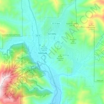
Name: Topografische Karte Sun Valley, Höhe, Relief.
Ort: Sun Valley, Blaine County, Idaho, United States (43.63996 -114.36125 43.72314 -114.30661)
Durchschnittliche Höhe: 1’988 m
Minimale Höhe: 1’724 m
Maximale Höhe: 2’780 m
Sun Valley is a resort city in the western United States, in Blaine County, Idaho, adjacent to the city of Ketchum in the Wood River valley. The population was 1406 at the 2010 census, down from 1427 in 2000. The elevation of Sun Valley (at the Lodge) is 5,920 feet (1,805 m) above sea level.
Andere topografische Karten
Klicken Sie auf eine Karte, um ihre Topografie, ihre Höhe und ihr Relief anzuzeigen.
Carey
United States > Idaho > Blaine County
Carey, Blaine County, Idaho, 83320, United States
Durchschnittliche Höhe: 1’467 m
Ketchum
United States > Idaho > Blaine County
Ketchum, Blaine County, Idaho, United States
Durchschnittliche Höhe: 1’906 m
Titus Lake
United States > Idaho > Blaine County
Titus Lake, Blaine County, Idaho, United States
Durchschnittliche Höhe: 2’736 m
Bellevue
United States > Idaho > Blaine County
Bellevue, Blaine County, Idaho, 83313, United States
Durchschnittliche Höhe: 1’667 m
Hailey
United States > Idaho > Blaine County
Hailey, Blaine County, Idaho, 83333, United States
Durchschnittliche Höhe: 1’729 m