
Topografische Karte Amelia County
Interaktive Karte
Klicken Sie auf die Karte, um die Höhe anzuzeigen.
Über diese Karte
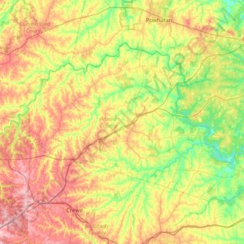
Name: Topografische Karte Amelia County, Höhe, Relief.
Ort: Amelia County, Virginia, United States (37.19221 -78.24129 37.49807 -77.64891)
Durchschnittliche Höhe: 103 m
Minimale Höhe: 46 m
Maximale Höhe: 187 m
Amelia County is drained by tributaries of the Appomattox. The lowest elevation in the county is 158 feet (48 m), on Lake Chesdin on the Appomattox at the eastern extremity of the county. The highest elevation is 525 feet (160 m), on SR 616 (S. Genito Road) at the community of Gills in the southwest corner of the county.