
Topografische Karte Williston
Interaktive Karte
Klicken Sie auf die Karte, um die Höhe anzuzeigen.
Über diese Karte
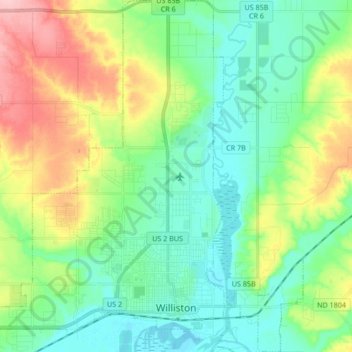
Name: Topografische Karte Williston, Höhe, Relief.
Ort: Williston, Williams County, North Dakota, United States (48.13255 -103.71236 48.24476 -103.56103)
Durchschnittliche Höhe: 603 m
Minimale Höhe: 559 m
Maximale Höhe: 699 m
Andere topografische Karten
Klicken Sie auf eine Karte, um ihre Topografie, ihre Höhe und ihr Relief anzuzeigen.
Tioga
United States > North Dakota > Williams County
Tioga, Williams County, North Dakota, 58852, United States
Durchschnittliche Höhe: 692 m
Wheelock
United States > North Dakota > Williams County > Wheelock
Wheelock, Williams County, North Dakota, United States
Durchschnittliche Höhe: 731 m
Williston
United States > North Dakota > Williams County > Williston
Williston, Williams County, North Dakota, 58801, United States
Durchschnittliche Höhe: 631 m
Epping
United States > North Dakota > Williams County > Epping
Epping, Williams County, North Dakota, United States
Durchschnittliche Höhe: 676 m