
Topografische Karte Minot
Interaktive Karte
Klicken Sie auf die Karte, um die Höhe anzuzeigen.
Über diese Karte
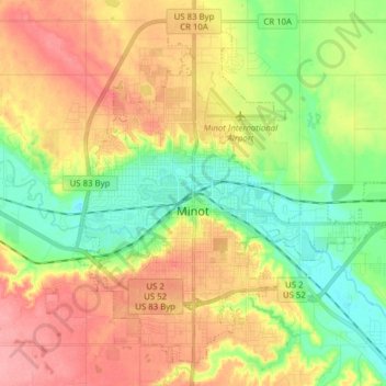
Name: Topografische Karte Minot, Höhe, Relief.
Ort: Minot, Ward County, North Dakota, United States (48.19164 -101.34295 48.28304 -101.18767)
Durchschnittliche Höhe: 510 m
Minimale Höhe: 467 m
Maximale Höhe: 558 m
The elevation of the river at the city center is 1,540 feet (470 m) above sea level. The valley sits 160 feet (49 m) below the surrounding plains; the elevation at the Minot International Airport on North Hill is 1,716 feet (523 m). The city has several small horseshoe-shaped oxbow lakes within its limits near the river, created by the Mouse's meandering course.
Andere topografische Karten
Klicken Sie auf eine Karte, um ihre Topografie, ihre Höhe und ihr Relief anzuzeigen.
Kenmare
United States > North Dakota > Ward County
Kenmare, Ward County, North Dakota, United States
Durchschnittliche Höhe: 577 m
Burlington
United States > North Dakota > Ward County
Burlington, Ward County, North Dakota, United States
Durchschnittliche Höhe: 500 m
Sawyer
United States > North Dakota > Ward County
Sawyer, Ward County, North Dakota, United States
Durchschnittliche Höhe: 488 m
Berthold
United States > North Dakota > Ward County > Berthold
Berthold, Ward County, North Dakota, United States
Durchschnittliche Höhe: 634 m