
Topografische Karte Byram cum Sutton
Interaktive Karte
Klicken Sie auf die Karte, um die Höhe anzuzeigen.
Über diese Karte
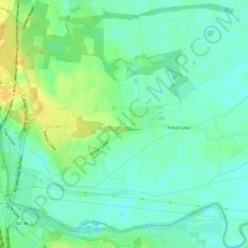
Name: Topografische Karte Byram cum Sutton, Höhe, Relief.
Durchschnittliche Höhe: 13 m
Minimale Höhe: 3 m
Maximale Höhe: 29 m
Andere topografische Karten
Klicken Sie auf eine Karte, um ihre Topografie, ihre Höhe und ihr Relief anzuzeigen.
Saxton
United Kingdom > England > Selby > Saxton
Saxton, Selby, North Yorkshire, Yorkshire and the Humber, England, LS24 9PZ, United Kingdom
Durchschnittliche Höhe: 32 m
Brotherton
United Kingdom > England > Selby > Brotherton
Brotherton, Selby, North Yorkshire, Yorkshire and the Humber, England, United Kingdom
Durchschnittliche Höhe: 16 m
Carlton
United Kingdom > England > Selby > Carlton
Carlton, Selby, North Yorkshire, Yorkshire and the Humber, England, DN14 9PB, United Kingdom
Durchschnittliche Höhe: 5 m
Hemingbrough
United Kingdom > England > Selby
Hemingbrough, Selby, North Yorkshire, Yorkshire and the Humber, England, United Kingdom
Durchschnittliche Höhe: 5 m
Carlton
United Kingdom > England > Selby
Carlton, Selby, North Yorkshire, Yorkshire and the Humber, England, United Kingdom
Durchschnittliche Höhe: 6 m
Beal
United Kingdom > England > Selby
Beal, Selby, North Yorkshire, Yorkshire and the Humber, England, United Kingdom
Durchschnittliche Höhe: 10 m
Brayton
United Kingdom > England > Selby
Brayton, Selby, North Yorkshire, Yorkshire and the Humber, England, United Kingdom
Durchschnittliche Höhe: 8 m
Camblesforth
United Kingdom > England > Selby
Camblesforth, Selby, North Yorkshire, Yorkshire and the Humber, England, United Kingdom
Durchschnittliche Höhe: 6 m
Kellington
United Kingdom > England > Selby
Kellington, Selby, North Yorkshire, Yorkshire and the Humber, England, United Kingdom
Durchschnittliche Höhe: 11 m