
Topografische Karte Kolhapur
Interaktive Karte
Klicken Sie auf die Karte, um die Höhe anzuzeigen.
Über diese Karte
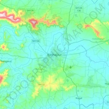
Name: Topografische Karte Kolhapur, Höhe, Relief.
Ort: Kolhapur, Maharashtra, 416003, India (16.54284 74.08053 16.86284 74.40053)
Durchschnittliche Höhe: 592 m
Minimale Höhe: 532 m
Maximale Höhe: 971 m
Kolhapur is an inland city located in south-west Maharashtra state, 373 km (232 mi) south of Mumbai and 228 km (142 mi) south of Pune, 615 km (382 mi) north-west of Bengaluru and 530 km (330 mi) west of Hyderabad. Within Maharashtra, Kolhapur's nearest cities and towns are Ichalkaranji 27 km (17 mi), Kodoli 35 km (22 mi), Peth Vadgaon 15 km (9.3 mi) Kagal 21 km (13 mi), Kasaba Walva 30 km (19 mi) Sangli 19 km (12 mi), Satara 115 km (71 mi). It lies in the Sahayadri mountains in the Western Ghats at an elevation of 569 m (1,867 ft). Tambraparni river dam near Umgaon village is close by, as also are Radhanagari and Kalambawadi dams. Panhala 21.5 km (13.4 mi) and Jyotiba Temple 21.7 km (13.5 mi) are in the vicinity of Kolhapur too.
Andere topografische Karten
Klicken Sie auf eine Karte, um ihre Topografie, ihre Höhe und ihr Relief anzuzeigen.
Ujalaiwadi
India > Maharashtra > Kolhapur
Ujalaiwadi, Kolhapur, Maharashtra, 416004, India
Durchschnittliche Höhe: 602 m
Kerle
India > Maharashtra > Kolhapur > Kerle
Kerle, Kolhapur, Kolhapur district, Maharashtra, India
Durchschnittliche Höhe: 599 m
Beed
India > Maharashtra > Kolhapur > Beed
Beed, Kolhapur, Kolhapur district, Maharashtra, India
Durchschnittliche Höhe: 555 m