
Topografische Karte Blackwell
Interaktive Karte
Klicken Sie auf die Karte, um die Höhe anzuzeigen.
Über diese Karte
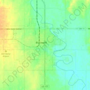
Name: Topografische Karte Blackwell, Höhe, Relief.
Ort: Blackwell, Kay County, Oklahoma, 74631, United States (36.78147 -97.34843 36.81873 -97.26939)
Durchschnittliche Höhe: 312 m
Minimale Höhe: 299 m
Maximale Höhe: 327 m
Andere topografische Karten
Klicken Sie auf eine Karte, um ihre Topografie, ihre Höhe und ihr Relief anzuzeigen.
Newkirk
United States > Oklahoma > Kay County
Newkirk, Kay County, Oklahoma, 74647, United States
Durchschnittliche Höhe: 350 m
Tonkawa
United States > Oklahoma > Kay County
Tonkawa, Kay County, Oklahoma, 74653, United States
Durchschnittliche Höhe: 300 m
Ponca City
United States > Oklahoma > Kay County
Ponca City, Kay County, Oklahoma, United States
Durchschnittliche Höhe: 308 m
Ponca City
United States > Oklahoma > Kay County > Ponca City > Ponca City
Ponca City, Kay County, Oklahoma, 74601, United States
Durchschnittliche Höhe: 302 m