
Topografische Karte Kothamangalam
Interaktive Karte
Klicken Sie auf die Karte, um die Höhe anzuzeigen.
Über diese Karte
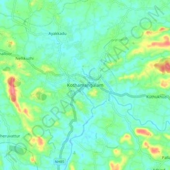
Name: Topografische Karte Kothamangalam, Höhe, Relief.
Ort: Kothamangalam, Ernakulam district, Kerala, 686666, India (10.02403 76.58182 10.10403 76.66182)
Durchschnittliche Höhe: 34 m
Minimale Höhe: 15 m
Maximale Höhe: 90 m
Kothamangalam is situated in the eastern part of the Ernakulam district. Kothamangalam is known as the Gateway of Highrange. According to the division of the geographical regions of Kerala, i.e. High-lands, Mid-lands and Low-lands, Kothamangalam is in a Mid-land region. The general topography is hilly. The Munnar hill station is around 85 kilometres from Kothamangalam.
Andere topografische Karten
Klicken Sie auf eine Karte, um ihre Topografie, ihre Höhe und ihr Relief anzuzeigen.
chelad kochappilly thodu
India > Kerala > Kothamangalam
chelad kochappilly thodu, Kothamangalam, Ernakulam district, Kerala, 686698, India
Durchschnittliche Höhe: 28 m