
Topografische Karte Cuyo
Interaktive Karte
Klicken Sie auf die Karte, um die Höhe anzuzeigen.
Über diese Karte
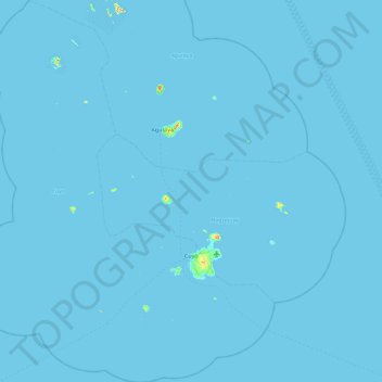
Name: Topografische Karte Cuyo, Höhe, Relief.
Ort: Cuyo, Palawan, Mimaropa, 5318, Philippines (10.55859 120.47054 11.46030 121.20413)
Durchschnittliche Höhe: 0 m
Minimale Höhe: -1 m
Maximale Höhe: 243 m
Cuyo Island is the largest island of the Cuyo Archipelago, about 13 kilometres (8.1 mi) long, 7.5 kilometres (4.7 mi) wide, and with an area of 57 square kilometres (22 sq mi). Mount Bonbon with an elevation of 817 ft (249 m) is the highest mountain in Cuyo island. The Island is under the jurisdiction of the municipalities of Cuyo and Magsaysay. The poblacion of Cuyo is home to a Spanish fort, which shelters a church and a convent in its high stone walls..