
Topografische Karte Waterloo
Interaktive Karte
Klicken Sie auf die Karte, um die Höhe anzuzeigen.
Über diese Karte
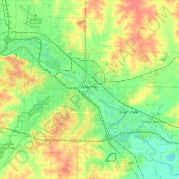
Name: Topografische Karte Waterloo, Höhe, Relief.
Ort: Waterloo, Black Hawk County, Iowa, United States (42.42116 -92.43682 42.57049 -92.24886)
Durchschnittliche Höhe: 272 m
Minimale Höhe: 246 m
Maximale Höhe: 307 m
The average elevation of Waterloo is 846 feet above sea level. The population density is 1101 people per square mile, considered low for an urban area.
Andere topografische Karten
Klicken Sie auf eine Karte, um ihre Topografie, ihre Höhe und ihr Relief anzuzeigen.
Evansdale
United States > Iowa > Black Hawk County
Evansdale, Black Hawk County, Iowa, 50707, United States
Durchschnittliche Höhe: 260 m
Dewar
United States > Iowa > Black Hawk County
Dewar, Black Hawk County, Iowa, 50623, United States
Durchschnittliche Höhe: 279 m
Benson
United States > Iowa > Black Hawk County
Benson, Black Hawk County, Iowa, United States
Durchschnittliche Höhe: 286 m
Washburn
United States > Iowa > Black Hawk County
Washburn, Black Hawk County, Iowa, 50706, United States
Durchschnittliche Höhe: 258 m
Hudson
United States > Iowa > Black Hawk County
Hudson, Black Hawk County, Iowa, United States
Durchschnittliche Höhe: 282 m
Dunkerton
United States > Iowa > Black Hawk County
Dunkerton, Black Hawk County, Iowa, 50626, United States
Durchschnittliche Höhe: 296 m
Voorhies
United States > Iowa > Black Hawk County
Voorhies, Black Hawk County, Iowa, United States
Durchschnittliche Höhe: 303 m
Finchford
United States > Iowa > Black Hawk County
Finchford, Black Hawk County, Iowa, United States
Durchschnittliche Höhe: 276 m
Eagle Center
United States > Iowa > Black Hawk County
Eagle Center, Black Hawk County, Iowa, United States
Durchschnittliche Höhe: 283 m
Gilbertville
United States > Iowa > Black Hawk County
Gilbertville, Black Hawk County, Iowa, 50634, United States
Durchschnittliche Höhe: 263 m
Elk Run Heights
United States > Iowa > Black Hawk County
Elk Run Heights, Black Hawk County, Iowa, United States
Durchschnittliche Höhe: 259 m
Cedar Falls
United States > Iowa > Black Hawk County
Cedar Falls, Black Hawk County, Iowa, United States
Durchschnittliche Höhe: 278 m
La Porte City
United States > Iowa > Black Hawk County
La Porte City, Black Hawk County, Iowa, 50651, United States
Durchschnittliche Höhe: 253 m
Raymond
United States > Iowa > Black Hawk County
Raymond, Black Hawk County, Iowa, 50667, United States
Durchschnittliche Höhe: 275 m
Waterloo
United States > Iowa > Black Hawk County > Waterloo
Waterloo, Black Hawk County, Iowa, 50701-1334, United States
Durchschnittliche Höhe: 282 m