
Topografische Karte Coronado
Interaktive Karte
Klicken Sie auf die Karte, um die Höhe anzuzeigen.
Über diese Karte
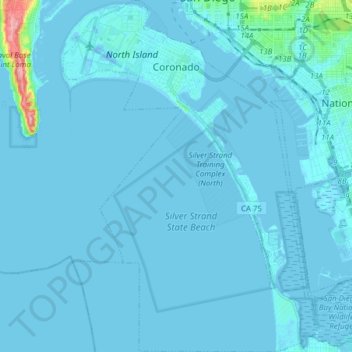
Name: Topografische Karte Coronado, Höhe, Relief.
Ort: Coronado, San Diego County, California, United States (32.58558 -117.22655 32.71615 -117.11448)
Durchschnittliche Höhe: 5 m
Minimale Höhe: -12 m
Maximale Höhe: 125 m
Andere topografische Karten
Klicken Sie auf eine Karte, um ihre Topografie, ihre Höhe und ihr Relief anzuzeigen.
Alpine
United States > California > San Diego County
Alpine, San Diego County, CAL Fire Southern Region, California, 91901, United States
Durchschnittliche Höhe: 581 m
San Diego
United States > California > San Diego County
San Diego, San Diego County, California, United States
Durchschnittliche Höhe: 125 m
Oceanside
United States > California > San Diego County
Oceanside, San Diego County, CAL Fire Southern Region, California, United States
Durchschnittliche Höhe: 33 m
Encinitas
United States > California > San Diego County
Encinitas, San Diego County, California, United States
Durchschnittliche Höhe: 32 m
Oak Park
United States > California > San Diego County > San Diego
Oak Park, San Diego, San Diego County, California, 92105, United States
Durchschnittliche Höhe: 108 m
Del Mar
United States > California > San Diego County > Del Mar
Del Mar, San Diego County, California, United States
Durchschnittliche Höhe: 24 m
Lemon Grove
United States > California > San Diego County
Lemon Grove, San Diego County, CAL Fire Southern Region, California, 91945, United States
Durchschnittliche Höhe: 129 m