
Topografische Karte Acadia National Park
Interaktive Karte
Klicken Sie auf die Karte, um die Höhe anzuzeigen.
Über diese Karte
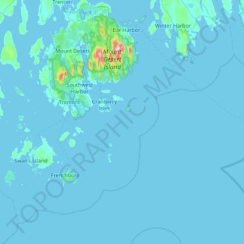
Name: Topografische Karte Acadia National Park, Höhe, Relief.
Durchschnittliche Höhe: 9 m
Minimale Höhe: -3 m
Maximale Höhe: 452 m
The ecological zones at Acadia National Park, from highest to lowest elevation, include: nearly barren mountain summits; northern boreal and eastern deciduous forests on the mountainsides; freshwater lakes and ponds, as well as wetlands like marshes and swamps in the valleys between mountains; and the Atlantic shoreline with rocky and sandy beaches, intertidal and subtidal zones.
Andere topografische Karten
Klicken Sie auf eine Karte, um ihre Topografie, ihre Höhe und ihr Relief anzuzeigen.
Fresh Meadow
United States > Maine > Hancock County > Bar Harbor
Fresh Meadow, Bar Harbor, Hancock County, Maine, United States
Durchschnittliche Höhe: 17 m
Cadillac Mountain
United States > Maine > Hancock County > Bar Harbor
Cadillac Mountain, Bar Harbor, Hancock County, Maine, 04609, United States
Durchschnittliche Höhe: 233 m
Salsbury Cove
United States > Maine > Hancock County > Bar Harbor
Salsbury Cove, Bar Harbor, Hancock County, Maine, United States
Durchschnittliche Höhe: 15 m