
Topografische Karte Louisiana
Interaktive Karte
Klicken Sie auf die Karte, um die Höhe anzuzeigen.
Über diese Karte
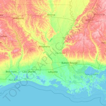
Name: Topografische Karte Louisiana, Höhe, Relief.
Ort: Louisiana, United States (28.85429 -94.04319 33.01959 -88.75833)
Durchschnittliche Höhe: 39 m
Minimale Höhe: -4 m
Maximale Höhe: 196 m
The higher and contiguous hill lands of the north and northwestern part of the state have an area of more than 25,000 square miles (65,000 km2). They consist of prairie and woodlands. The elevations above sea level range from 10 feet (3 m) at the coast and swamp lands to 50–60 feet (15–18 m) at the prairie and alluvial lands. In the uplands and hills, the elevations rise to Driskill Mountain, the highest point in the state only 535 feet (163 m) above sea level. From 1932 to 2010 the state lost 1,800 square miles due to rises in sea level and erosion. The Louisiana Coastal Protection and Restoration Authority (CPRA) spends around $1 billion per year to help shore up and protect Louisiana shoreline and land in both federal and state funding.
Andere topografische Karten
Klicken Sie auf eine Karte, um ihre Topografie, ihre Höhe und ihr Relief anzuzeigen.
Appalachian Mountains
United States > North Carolina > Yancey County
Appalachian Mountains, Yancey County, North Carolina, United States
Durchschnittliche Höhe: 1’463 m
Albuquerque
United States > New Mexico > Bernalillo County
Albuquerque, Bernalillo County, New Mexico, United States
Durchschnittliche Höhe: 1’688 m
Los Angeles
Los Angeles, California, United States
Durchschnittliche Höhe: 241 m
Safety Harbor
United States > Florida > Pinellas County
Safety Harbor, Pinellas County, Florida, 34695, United States
Durchschnittliche Höhe: 11 m
New Haven
United States > Connecticut > New Haven County > New Haven
New Haven, New Haven County, Connecticut, United States
Durchschnittliche Höhe: 22 m
Arlington
United States > Massachusetts > Middlesex County
Arlington, Middlesex County, Massachusetts, United States
Durchschnittliche Höhe: 35 m
Brooklyn
United States > New York > New York
Brooklyn, Kings County, New York, United States
Durchschnittliche Höhe: 9 m
Breckenridge
United States > Colorado > Summit County
Breckenridge, Summit County, Colorado, 80424, United States
Durchschnittliche Höhe: 3’072 m
Baldwin County
Baldwin County, Alabama, United States
Durchschnittliche Höhe: 31 m
Littleton
United States > Colorado > Arapahoe County
Littleton, Arapahoe County, Colorado, United States
Durchschnittliche Höhe: 1’684 m
Jacksonville
United States > Florida > Duval County
Jacksonville, Duval County, Florida, United States
Durchschnittliche Höhe: 10 m
Midland
United States > Texas > Midland County
Midland, Midland County, Texas, United States
Durchschnittliche Höhe: 855 m
Marquette County
Marquette County, Michigan, United States
Durchschnittliche Höhe: 332 m
Manhattan
United States > New York > New York County > New York
Manhattan, New York County, New York, United States
Durchschnittliche Höhe: 16 m
Moab
United States > Utah > Grand County
Moab, Grand County, Utah, 84532, United States
Durchschnittliche Höhe: 1’357 m
Hudson River
Hudson River, New Jersey, 12834:12871, United States
Durchschnittliche Höhe: 297 m
Des Moines
United States > Iowa > Polk County
Des Moines, Polk County, Iowa, United States
Durchschnittliche Höhe: 264 m
Houston
United States > Texas > Harris County
Houston, Harris County, Texas, United States
Durchschnittliche Höhe: 25 m
New Orleans
United States > Louisiana > Orleans Parish
New Orleans, Orleans Parish, Louisiana, United States
Durchschnittliche Höhe: 1 m
Santa Cruz
United States > California > Santa Cruz County
Santa Cruz, Santa Cruz County, California, United States
Durchschnittliche Höhe: 89 m
West Liberty
United States > West Virginia > Ohio County
West Liberty, Ohio County, West Virginia, United States
Durchschnittliche Höhe: 354 m