
Topografische Karte Killingworth
Interaktive Karte
Klicken Sie auf die Karte, um die Höhe anzuzeigen.
Über diese Karte
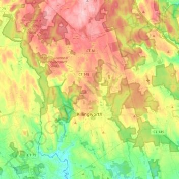
Name: Topografische Karte Killingworth, Höhe, Relief.
Durchschnittliche Höhe: 102 m
Minimale Höhe: 3 m
Maximale Höhe: 208 m
Andere topografische Karten
Klicken Sie auf eine Karte, um ihre Topografie, ihre Höhe und ihr Relief anzuzeigen.
East Hampton
United States > Connecticut > Lower Connecticut River Valley Planning Region > East Hampton
East Hampton, Lower Connecticut River Valley Planning Region, Connecticut, 06424, United States
Durchschnittliche Höhe: 143 m
Dooley Pond
United States > Connecticut > Lower Connecticut River Valley Planning Region > Middletown
Dooley Pond, Middletown, Lower Connecticut River Valley Planning Region, Connecticut, United States
Durchschnittliche Höhe: 97 m
Pameacha Pond
United States > Connecticut > Lower Connecticut River Valley Planning Region > Middletown
Pameacha Pond, Bretton Heights, Middletown, Lower Connecticut River Valley Planning Region, Connecticut, United States
Durchschnittliche Höhe: 41 m
Middletown
United States > Connecticut > Lower Connecticut River Valley Planning Region
Middletown, Lower Connecticut River Valley Planning Region, Connecticut, United States
Durchschnittliche Höhe: 76 m
Clinton
United States > Connecticut > Lower Connecticut River Valley Planning Region
Clinton, Lower Connecticut River Valley Planning Region, Connecticut, 06413, United States
Durchschnittliche Höhe: 27 m
Field Park
United States > Connecticut > Lower Connecticut River Valley Planning Region > Middletown > Newfield Heights
Field Park, Newfield Heights, Middletown, Lower Connecticut River Valley Planning Region, Connecticut, United States
Durchschnittliche Höhe: 39 m
Westbrook Center
United States > Connecticut > Lower Connecticut River Valley Planning Region > Westbrook
Westbrook Center, Westbrook, Lower Connecticut River Valley Planning Region, Connecticut, United States
Durchschnittliche Höhe: 7 m
Essex Village
United States > Connecticut > Lower Connecticut River Valley Planning Region > Essex
Essex Village, Essex, Lower Connecticut River Valley Planning Region, Connecticut, United States
Durchschnittliche Höhe: 22 m
Lake Pocotopaug
United States > Connecticut > Lower Connecticut River Valley Planning Region > East Hampton
Lake Pocotopaug, East Hampton, Lower Connecticut River Valley Planning Region, Connecticut, 06424, United States
Durchschnittliche Höhe: 184 m
Chester Center
United States > Connecticut > Lower Connecticut River Valley Planning Region > Chester
Chester Center, Chester, Lower Connecticut River Valley Planning Region, Connecticut, 06412, United States
Durchschnittliche Höhe: 52 m
Oxford Park
United States > Connecticut > Lower Connecticut River Valley Planning Region > Cromwell
Oxford Park, Cromwell, Lower Connecticut River Valley Planning Region, Connecticut, 06416, United States
Durchschnittliche Höhe: 32 m
Old Lyme
United States > Connecticut > Lower Connecticut River Valley Planning Region
Old Lyme, Lower Connecticut River Valley Planning Region, Connecticut, United States
Durchschnittliche Höhe: 19 m
Johnsonville
United States > Connecticut > Lower Connecticut River Valley Planning Region > East Haddam > Moodus
Johnsonville, Moodus, East Haddam, Lower Connecticut River Valley Planning Region, Connecticut, 06469, United States
Durchschnittliche Höhe: 58 m
Pond Meadow
United States > Connecticut > Lower Connecticut River Valley Planning Region > Westbrook
Pond Meadow, Westbrook, Lower Connecticut River Valley Planning Region, Connecticut, 06442, United States
Durchschnittliche Höhe: 53 m
Pocotopaug Lake
United States > Connecticut > Lower Connecticut River Valley Planning Region > East Hampton > Lake Pocotopaug
Pocotopaug Lake, Lake Pocotopaug, East Hampton, Lower Connecticut River Valley Planning Region, Connecticut, United States
Durchschnittliche Höhe: 156 m
Clinton
United States > Connecticut > Lower Connecticut River Valley Planning Region > Clinton
Clinton, Lower Connecticut River Valley Planning Region, Connecticut, United States
Durchschnittliche Höhe: 7 m
East Hampton
United States > Connecticut > Lower Connecticut River Valley Planning Region
East Hampton, Lower Connecticut River Valley Planning Region, Connecticut, United States
Durchschnittliche Höhe: 129 m
Middlesex County
United States > Connecticut > Lower Connecticut River Valley Planning Region
Middlesex County, Lower Connecticut River Valley Planning Region, Connecticut, United States
Durchschnittliche Höhe: 81 m
East Haddam
United States > Connecticut > Lower Connecticut River Valley Planning Region
East Haddam, Lower Connecticut River Valley Planning Region, Connecticut, United States
Durchschnittliche Höhe: 96 m
Old Saybrook
United States > Connecticut > Lower Connecticut River Valley Planning Region
Old Saybrook, Lower Connecticut River Valley Planning Region, Connecticut, 06475, United States
Durchschnittliche Höhe: 11 m
Cromwell
United States > Connecticut > Lower Connecticut River Valley Planning Region
Cromwell, Lower Connecticut River Valley Planning Region, Connecticut, 06416, United States
Durchschnittliche Höhe: 30 m
Durham
United States > Connecticut > Lower Connecticut River Valley Planning Region
Durham, Lower Connecticut River Valley Planning Region, Connecticut, 06422, United States
Durchschnittliche Höhe: 121 m
Westbrook
United States > Connecticut > Lower Connecticut River Valley Planning Region
Westbrook, Lower Connecticut River Valley Planning Region, Connecticut, 06498, United States
Durchschnittliche Höhe: 24 m
Haddam
United States > Connecticut > Lower Connecticut River Valley Planning Region
Haddam, Lower Connecticut River Valley Planning Region, Connecticut, United States
Durchschnittliche Höhe: 96 m
Middlefield
United States > Connecticut > Lower Connecticut River Valley Planning Region
Middlefield, Lower Connecticut River Valley Planning Region, Connecticut, United States
Durchschnittliche Höhe: 101 m
Lyme
United States > Connecticut > Lower Connecticut River Valley Planning Region
Lyme, Lower Connecticut River Valley Planning Region, Connecticut, United States
Durchschnittliche Höhe: 49 m