
Topografische Karte Webster City
Interaktive Karte
Klicken Sie auf die Karte, um die Höhe anzuzeigen.
Über diese Karte
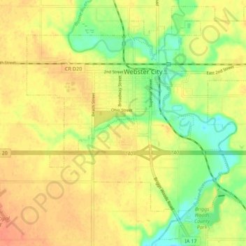
Name: Topografische Karte Webster City, Höhe, Relief.
Ort: Webster City, Hamilton County, Iowa, 50595, United States (42.42727 -93.85809 42.48596 -93.77428)
Durchschnittliche Höhe: 328 m
Minimale Höhe: 304 m
Maximale Höhe: 343 m
Andere topografische Karten
Klicken Sie auf eine Karte, um ihre Topografie, ihre Höhe und ihr Relief anzuzeigen.
Randall
United States > Iowa > Hamilton County
Randall, Hamilton County, Iowa, 50231, United States
Durchschnittliche Höhe: 313 m
Stratford
United States > Iowa > Hamilton County
Stratford, Hamilton County, Iowa, United States
Durchschnittliche Höhe: 336 m
Jewell Junction
United States > Iowa > Hamilton County
Jewell Junction, Hamilton County, Iowa, United States
Durchschnittliche Höhe: 324 m
Blairsburg
United States > Iowa > Hamilton County
Blairsburg, Hamilton County, Iowa, United States
Durchschnittliche Höhe: 373 m
Kamrar
United States > Iowa > Hamilton County
Kamrar, Hamilton County, Iowa, United States
Durchschnittliche Höhe: 337 m
Williams
United States > Iowa > Hamilton County
Williams, Hamilton County, Iowa, United States
Durchschnittliche Höhe: 365 m
Stanhope
United States > Iowa > Hamilton County
Stanhope, Hamilton County, Iowa, United States
Durchschnittliche Höhe: 337 m
Ellsworth
United States > Iowa > Hamilton County
Ellsworth, Hamilton County, Iowa, 50075, United States
Durchschnittliche Höhe: 332 m