
Topografische Karte Monticello
Interaktive Karte
Klicken Sie auf die Karte, um die Höhe anzuzeigen.
Über diese Karte
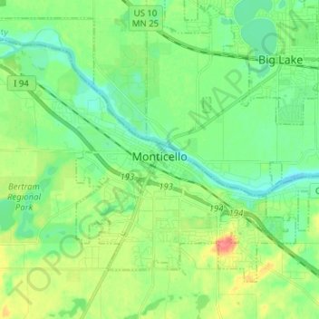
Name: Topografische Karte Monticello, Höhe, Relief.
Ort: Monticello, Wright County, Minnesota, 55362, United States (45.27053 -93.86106 45.33840 -93.73503)
Durchschnittliche Höhe: 289 m
Minimale Höhe: 270 m
Maximale Höhe: 327 m
According to the U.S. Census Bureau, the city has a total area of 8.94 square miles (23.15 km2), all land. The city's latitude is 45.305 degrees North and its longitude is 93.793 degrees West. Its elevation is 922 feet. Monticello is in the Central time zone.
Andere topografische Karten
Klicken Sie auf eine Karte, um ihre Topografie, ihre Höhe und ihr Relief anzuzeigen.
Rockford
United States > Minnesota > Wright County
Rockford, Wright County, Minnesota, United States
Durchschnittliche Höhe: 296 m
Delano
United States > Minnesota > Wright County
Delano, Wright County, Minnesota, 55328, United States
Durchschnittliche Höhe: 289 m
Otsego
United States > Minnesota > Wright County
Otsego, Wright County, Minnesota, United States
Durchschnittliche Höhe: 281 m
Monticello Township
United States > Minnesota > Wright County
Monticello Township, Wright County, Minnesota, United States
Durchschnittliche Höhe: 297 m
Albertville
United States > Minnesota > Wright County
Albertville, Wright County, Minnesota, 55301, United States
Durchschnittliche Höhe: 292 m
Hanover
United States > Minnesota > Wright County
Hanover, Wright County, Minnesota, 55341, United States
Durchschnittliche Höhe: 291 m
Montrose
United States > Minnesota > Wright County
Montrose, Wright County, Minnesota, United States
Durchschnittliche Höhe: 294 m
Howard Lake
United States > Minnesota > Wright County
Howard Lake, Wright County, Minnesota, 55349, United States
Durchschnittliche Höhe: 312 m
Buffalo
United States > Minnesota > Wright County
Buffalo, Wright County, Minnesota, 55313, United States
Durchschnittliche Höhe: 297 m
Silver Creek Township
United States > Minnesota > Wright County
Silver Creek Township, Wright County, Minnesota, 55380, United States
Durchschnittliche Höhe: 303 m
Albion Center
United States > Minnesota > Wright County
Albion Center, Albion Township, Wright County, Minnesota, United States
Durchschnittliche Höhe: 320 m
Maple Lake Township
United States > Minnesota > Wright County
Maple Lake Township, Wright County, Minnesota, 55358, United States
Durchschnittliche Höhe: 310 m
St. Michael
United States > Minnesota > Wright County
St. Michael, Wright County, Minnesota, 55376, United States
Durchschnittliche Höhe: 290 m
South Haven
United States > Minnesota > Wright County
South Haven, Wright County, Minnesota, United States
Durchschnittliche Höhe: 333 m
Maple Lake
United States > Minnesota > Wright County > Maple Lake > Maple Lake
Maple Lake, Wright County, Minnesota, 55358, United States
Durchschnittliche Höhe: 314 m
South Haven
United States > Minnesota > Wright County > South Haven > South Haven
South Haven, Wright County, Minnesota, 55382, United States
Durchschnittliche Höhe: 331 m
Rockford
United States > Minnesota > Wright County > Rockford > Rockford
Rockford, Wright County, Minnesota, 55313:55373, United States
Durchschnittliche Höhe: 298 m
Annandale
United States > Minnesota > Wright County > Annandale > Annandale
Annandale, Wright County, Minnesota, 55302, United States
Durchschnittliche Höhe: 324 m
Annandale
United States > Minnesota > Wright County
Annandale, Wright County, Minnesota, 55302, United States
Durchschnittliche Höhe: 323 m
Maple Lake
United States > Minnesota > Wright County
Maple Lake, Wright County, Minnesota, United States
Durchschnittliche Höhe: 314 m