
Topografische Karte Mount Greylock
Interaktive Karte
Klicken Sie auf die Karte, um die Höhe anzuzeigen.
Über diese Karte
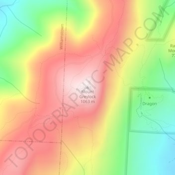
Name: Topografische Karte Mount Greylock, Höhe, Relief.
Durchschnittliche Höhe: 746 m
Minimale Höhe: 386 m
Maximale Höhe: 1’062 m
Geographically, Mount Greylock is part of an 11-mile-long (18 km) by 4+1⁄2-mile-wide (7 km) island-like range that runs north-south between the Hoosac Range to the east, the Green Mountains to the north, the Berkshires to both the south and east, and the Taconic Mountains to the west with which it is geologically associated; all ranges are associated with the Appalachian mountain chain. The summit of Mount Greylock is located in Adams, Massachusetts, but the mountain also extends into Cheshire, Lanesborough, New Ashford, North Adams and Williamstown. The range includes peaks with elevation less than Greylock, such as Saddle Ball Mountain and Mount Fitch.
Andere topografische Karten
Klicken Sie auf eine Karte, um ihre Topografie, ihre Höhe und ihr Relief anzuzeigen.
Maple Grove
United States > Massachusetts > Berkshire County > Adams
Maple Grove, Adams, Berkshire County, Massachusetts, 01220, United States
Durchschnittliche Höhe: 342 m