
Topografische Karte Melba
Interaktive Karte
Klicken Sie auf die Karte, um die Höhe anzuzeigen.
Über diese Karte
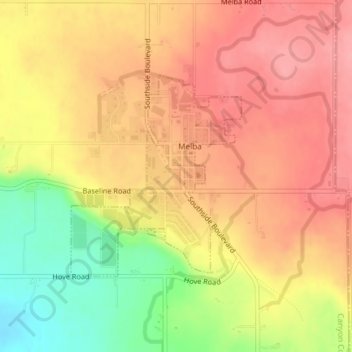
Name: Topografische Karte Melba, Höhe, Relief.
Ort: Melba, Canyon County, Idaho, United States (43.36544 -116.54158 43.38086 -116.52360)
Durchschnittliche Höhe: 798 m
Minimale Höhe: 733 m
Maximale Höhe: 837 m
Melba is located at 43°22′25″N 116°31′45″W / 43.37361°N 116.52917°W / 43.37361; -116.52917 (43.373487, -116.529194). at an elevation of 2,667 feet (813 m) above sea level. It is 12 miles (19 km) south of Nampa, and three miles (5 km) northeast of the Snake River.
Andere topografische Karten
Klicken Sie auf eine Karte, um ihre Topografie, ihre Höhe und ihr Relief anzuzeigen.
Nampa
United States > Idaho > Canyon County
Nampa, Canyon County, Idaho, United States
Durchschnittliche Höhe: 764 m
Caldwell
United States > Idaho > Canyon County
Caldwell, Canyon County, Idaho, United States
Durchschnittliche Höhe: 742 m
Middleton
United States > Idaho > Canyon County
Middleton, Canyon County, Idaho, 83644, United States
Durchschnittliche Höhe: 741 m
Nampa
United States > Idaho > Canyon County > Nampa
Nampa, Canyon County, Idaho, 83686, United States
Durchschnittliche Höhe: 783 m
Parma
United States > Idaho > Canyon County
Parma, Canyon County, Idaho, 83660, United States
Durchschnittliche Höhe: 686 m
Notus
United States > Idaho > Canyon County
Notus, Canyon County, Idaho, 83656, United States
Durchschnittliche Höhe: 708 m