
Topografische Karte Felanitx
Interaktive Karte
Klicken Sie auf die Karte, um die Höhe anzuzeigen.
Über diese Karte
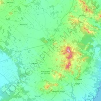
Name: Topografische Karte Felanitx, Höhe, Relief.
Ort: Felanitx, Migjorn, Islas Baleares, España (39.37598 3.05969 39.53531 3.27725)
Durchschnittliche Höhe: 101 m
Minimale Höhe: 0 m
Maximale Höhe: 471 m
Andere topografische Karten
Klicken Sie auf eine Karte, um ihre Topografie, ihre Höhe und ihr Relief anzuzeigen.
Puig de Ros
España > Islas Baleares > Migjorn
Puig de Ros, Lluchmayor, Migjorn, Islas Baleares, 07609, España
Durchschnittliche Höhe: 75 m
Son Salom
España > Islas Baleares > Migjorn > Santañí
Son Salom, Santañí, Migjorn, Islas Baleares, 07650, España
Durchschnittliche Höhe: 54 m
Lluchmayor
España > Islas Baleares > Migjorn
Lluchmayor, Migjorn, Islas Baleares, España
Durchschnittliche Höhe: 89 m
Lluchmayor
España > Islas Baleares > Migjorn
Lluchmayor, Migjorn, Islas Baleares, 07620, España
Durchschnittliche Höhe: 164 m
Porto Petro
España > Islas Baleares > Migjorn > Santañí
Porto Petro, Santañí, Migjorn, Islas Baleares, 07691, España
Durchschnittliche Höhe: 16 m
Cala Egos
España > Islas Baleares > Migjorn > Santañí
Cala Egos, Santañí, Migjorn, Islas Baleares, 07660, España
Durchschnittliche Höhe: 11 m
Cala d'Or
España > Islas Baleares > Migjorn > Santañí
Cala d'Or, Santañí, Migjorn, Islas Baleares, 07660, España
Durchschnittliche Höhe: 17 m
Sa Bassa
España > Islas Baleares > Migjorn > Felanitx
Sa Bassa, Felanitx, Migjorn, Islas Baleares, 07200, España
Durchschnittliche Höhe: 84 m