
Topografische Karte Glyn-neath
Interaktive Karte
Klicken Sie auf die Karte, um die Höhe anzuzeigen.
Über diese Karte
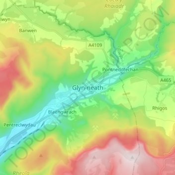
Name: Topografische Karte Glyn-neath, Höhe, Relief.
Ort: Glyn-neath, Neath Port Talbot, Wales, SA11 5AY, United Kingdom (51.70841 -3.65693 51.78841 -3.57693)
Durchschnittliche Höhe: 253 m
Minimale Höhe: 26 m
Maximale Höhe: 603 m
Andere topografische Karten
Klicken Sie auf eine Karte, um ihre Topografie, ihre Höhe und ihr Relief anzuzeigen.
Briton Ferry
United Kingdom > Wales > Neath Port Talbot
Briton Ferry, Neath Port Talbot, Wales, SA11 2NH, United Kingdom
Durchschnittliche Höhe: 69 m
Warren Hill
United Kingdom > Wales > Neath Port Talbot > Briton Ferry
Warren Hill, Briton Ferry, Neath Port Talbot, Wales, SA11, United Kingdom
Durchschnittliche Höhe: 30 m
Blaengwynfi
United Kingdom > Wales > Neath Port Talbot > Blaengwynfi
Blaengwynfi, Neath Port Talbot, Wales, SA13 3TB, United Kingdom
Durchschnittliche Höhe: 412 m
Port Talbot
United Kingdom > Wales > Neath Port Talbot
Port Talbot, Neath Port Talbot, Wales, SA13 1LY, United Kingdom
Durchschnittliche Höhe: 76 m