
Topografische Karte Liskamm westlicher Vorgipfel
Interaktive Karte
Klicken Sie auf die Karte, um die Höhe anzuzeigen.
Über diese Karte
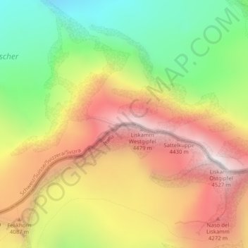
Name: Topografische Karte Liskamm westlicher Vorgipfel, Höhe, Relief.
Durchschnittliche Höhe: 3’813 m
Minimale Höhe: 3’085 m
Maximale Höhe: 4’531 m
Andere topografische Karten
Klicken Sie auf eine Karte, um ihre Topografie, ihre Höhe und ihr Relief anzuzeigen.
Schwarzsee
Schwarzsee, Hörnligrat, Chalbermatten, Zermatt, Visp, Wallis, 3920, Schweiz
Durchschnittliche Höhe: 2’499 m
Dufourspitze (Monte Rosa)
Dufourspitze (Monte Rosa), Zermatt, Visp, Wallis, 3920, Schweiz
Durchschnittliche Höhe: 4’033 m
Parrotspitze
Parrotspitze, Zermatt, Visp, Wallis, 3920, Schweiz
Durchschnittliche Höhe: 3’887 m
Durandgletscher
Durandgletscher, Arbengrat, Chalbermatten, Zermatt, Visp, Wallis, 3920, Schweiz
Durchschnittliche Höhe: 3’163 m
Zumsteinspitze
Zumsteinspitze, Zermatt, Visp, Wallis, 3920, Schweiz
Durchschnittliche Höhe: 4’001 m
Unterrothorn
Unterrothorn, Zermatt, Visp, Wallis, 3920, Schweiz
Durchschnittliche Höhe: 2’715 m
Walliser Alpen
Walliser Alpen, Zermatt, Visp, Wallis, 3920, Schweiz
Durchschnittliche Höhe: 3’842 m