
Topografische Karte Hail Creek
Interaktive Karte
Klicken Sie auf die Karte, um die Höhe anzuzeigen.
Über diese Karte
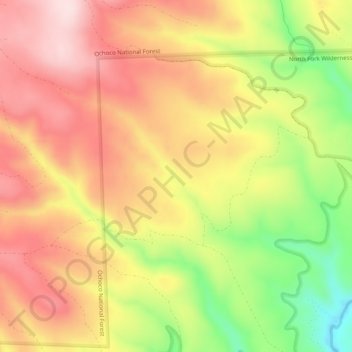
Name: Topografische Karte Hail Creek, Höhe, Relief.
Ort: Hail Creek, Crook County, Oregon, United States of America (44.22241 -120.17710 44.24846 -120.12697)
Durchschnittliche Höhe: 1’412 m
Minimale Höhe: 1’215 m
Maximale Höhe: 1’555 m
Andere topografische Karten
Klicken Sie auf eine Karte, um ihre Topografie, ihre Höhe und ihr Relief anzuzeigen.
Boring
United States of America > Oregon > Boring
Boring, Clackamas County, Oregon, 97009, United States of America
Durchschnittliche Höhe: 183 m
Rhododendron
United States of America > Oregon > Rhododendron
Rhododendron, The Villages at Mount Hood, Clackamas County, Oregon, 97049, United States of America
Durchschnittliche Höhe: 735 m
Iron Knob
United States of America > Oregon
Iron Knob, Jackson County, Oregon, United States of America
Durchschnittliche Höhe: 861 m
Morton Island
United States of America > Oregon
Morton Island, Malheur County, Oregon, United States of America
Durchschnittliche Höhe: 661 m
Wemme
United States of America > Oregon > Wemme
Wemme, The Villages at Mount Hood, Clackamas County, Oregon, 97067, United States of America
Durchschnittliche Höhe: 494 m
Barlow
United States of America > Oregon > Barlow
Barlow, Clackamas County, Oregon, United States of America
Durchschnittliche Höhe: 31 m
Lake County
United States of America > Oregon
Lake County, Oregon, United States of America
Durchschnittliche Höhe: 1’540 m
McKenzie River
United States of America > Oregon
McKenzie River, Lane County, Oregon, 97413, United States of America
Durchschnittliche Höhe: 431 m
Hillsboro
United States of America > Oregon > Hillsboro
Hillsboro, Washington County, Oregon, United States of America
Durchschnittliche Höhe: 53 m